
Lonsee
| coat of arms | Germany map | |
|---|---|---|

|
Coordinates: 48 ° 33 ' N , 9 ° 55' E |
|
| Basic data | ||
| State : | Baden-Württemberg | |
| Administrative region : | Tübingen | |
| County : | Alb-Danube district | |
| Height : | 564 m above sea level NHN | |
| Area : | 43.32 km 2 | |
| Residents: | 4993 (December 31, 2018) | |
| Population density : | 115 inhabitants per km 2 | |
| Postal code : | 89173 | |
| Area code : | 07336 | |
| License plate : | UL | |
| Community key : | 08 4 25 075 | |
| LOCODE : | DE LS3 | |
| Community structure: | 7 sub-locations | |
| Address of the municipal administration: |
Hindenburgstrasse 16 89173 Lonsee |
|
| Website : | ||
| Mayor : | Jochen Ogger | |
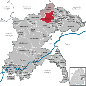
| Location of the municipality of Lonsee in the Alb-Donau district | ||
  |
||

Lonsee is a municipality in the Alb-Donau district in Baden-Württemberg .
geography
Geographical location
Lonsee is located at the beginning of the Lone Valley on the Swabian Alb , about 15 km northwest of Ulm and about ten kilometers southeast of Geislingen an der Steige .
Neighboring communities
The municipality borders Amstetten in the north, Weidenstetten in the east, Westerstetten and Dornstadt in the south and Nellingen in the west . All communities are in the Alb-Donau district.
Community structure
In addition to the core town of Lonsee, the municipality also includes the suburbs Ettlenschieß , Luizhausen , Halzhausen , Radelstetten , Sinabronn and Urspring .

history
prehistory
Due to the location at a Alb crossing, a settlement since the Neolithic can be proven in Urspring . The finds from the Haldenstein cave , which Gustav Riek examined in 1938, are even older . What is remarkable is the discovery of a leaf tip that dates back to the early Upper Paleolithic, i.e. the time around 50,000 BC. Is to be assigned. The Haldenstein cave is the westernmost of the Paleolithic sites along the Lone Valley .
Roman time

Above the village of Urspring is the former Roman fort Ad Lunam , a border fort of the so-called Alblimes , the exact time of its foundation is still being discussed in archeology . In the valley itself there was an associated civilian settlement ( vicus ), which in recent years has been built over largely unobserved.
middle Ages
Lonsee was first mentioned in a document in 888 . Archaeological finds near Urspring show an early Halemannic settlement in the 5th century and subsequently a settlement since at least the 7th century.
In the High Middle Ages, Lonsee belonged to the Count Palatine of Tübingen and later to the Count of Helfenstein and was fortified with walls and gate towers. In 1396 Ulm acquired the place. The imperial city of Ulm established an office of the lower rule in Lonsee.
Modern times
In 1803 Lonsee fell to the Electorate of Bavaria and in 1810 to the Kingdom of Württemberg . Lonsee was subordinated to the Oberamt Ulm . In 1850, when the Filstalbahn was expanded over the Geislinger Steige to Ulm, it was connected to the Württemberg railway network .
During the district reform during the Nazi era in Württemberg in 1938, Lonsee came to the Ulm district . In 1945 the place became part of the American zone of occupation and thus belonged to the newly founded state of Württemberg-Baden , which was incorporated into the current state of Baden-Württemberg in 1952. Due to the district reform in Baden-Württemberg , Lonsee became part of the Alb-Donau district in 1973 .
Districts


Origin
 |

Karst spring Lonetopf in the district of Urspring
After the core town of Lonsee, Urspring is the largest district. It was first mentioned in 1108 as Urspringam and around 1255 as Urspringe . The name means "settlement at the source". The lone rises there in a, compared to the Blautopf , a small spring pot that is 6 m deep and 10 m in diameter. Northeast of the town center on the "Herberg" was in the 1st / 2nd. Century AD a Roman cohort fort and an associated vicus . The name of the settlement is not directly proven from the archaeological findings, but the identification with the Ad Lunam mentioned in the Tabula Peutingeriana is obvious due to the meaning of the name. The Latin place name "Ad Lunam" is not derived from the Latin "Luna" (the moon), but refers to the Latinized form of the river name "Lone", which means something like "At the Lone". The place had strategic importance in Roman times as part of the Alblimes and station of the Roman road Mainz-Augsburg. The Romans use the Lone spring as well as the favorable location of the place on the Albaufstieg . Alamannic settlement remains found on the eastern edge of the village and south of the present-day town show Urspring as one of the earliest settlements in the upper Lone Valley. However, there is no evidence of settlement continuity since Roman times. In the High Middle Ages, Urspring belonged to the County of Helfenstein. In 1382 the place was pledged to Ulm and sold in 1396. When it belonged to the imperial city of Ulm, Urspring belonged to the Lonsee office. Originally fell to Bavaria in 1803 and to Württemberg in 1810. The place was subordinated to the Oberamt Ulm . Origining has belonged to the Ulm district since 1938 . Urspring has 880 inhabitants (as of December 31, 2018). |

Halzhausen
 |
Halzhausen is a small district with 607 inhabitants (as of December 31, 2018), which is directly connected to the main town of Lonsee.
Halzhausen is first mentioned together with Lonsee in 1108 as Halhusam, a little later as Aleshusen (chronicles 1521) and only in 1382 as Halshusen. The name means "settlement of Hadulf". The settlement probably originated from Lonsee, with which it always remained in close lordship and ecclesiastical relations. Halzhausen is still part of the Lonsee parish today. At the beginning of the 12th century, the place probably only consisted of one or two farms, which were later divided, which led to the settlement of several farms. In 1802, Halzhausen already consisted of 24 houses and an inn due to the population development. In 1803 Halzhausen fell to Bavaria and in 1810 to Württemberg. The place was subordinated to the Oberamt Ulm . Since 1938 Halzhausen belonged to the district of Ulm . Halzhausen was incorporated into Lonsee on April 1, 1972 as part of the municipal reform. |

Ettlenschieß
 |
Ettlenschieß is located north of Lonsee, has 488 inhabitants (as of December 31, 2018) and is located directly on the famous Way of St. James (pilgrimage to Santiago de Compostela). The place belonged to the Albeck rule. It was sold to the imperial city of Ulm by the Counts of Werdenberg in 1385 with the rule of Albeck. In 1803 Ettlenschieß fell to Bavaria and in 1810 to Württemberg. The place was subordinated to the Oberamt Ulm. Since 1938 Ettlenschieß belonged to the district of Ulm. The place was incorporated into Lonsee on April 1, 1972. |
Luizhausen
 |
Luizhausen is located on the old long-distance and post road from Vienna to Paris . Since the place lies exactly in the middle between the two important cities, it was an important post station where old, tired horses were exchanged for new horses for the further journey. In the Middle Ages, the Lords of Westerstetten owned the place as feudal men of the County of Helfenstein and the County of Württemberg . In 1485 the rulership rights and the property in Luizhausen fell through sale to the imperial city of Ulm. In the course of mediatization, Luizhausen came to Bavaria in 1803 and to Württemberg in 1810. Luizhausen was subordinated to the Oberamt Ulm and had belonged to the Ulm district since 1938. Today Luizhausen is located on Bundesstrasse 10 , the successor to the old Poststrasse. After years of dispute, a bypass road has existed since 2006 , so that the traffic of the B10 no longer has to run through the center of the town. On April 1, 1972, Luizhausen was incorporated into Lonsee as part of the community reform. 342 people live in Luizhausen (as of December 31, 2018). Accordion players from all over Germany know Luizhausen because Hans Hemgesberg , one of the few accordion builders in Germany, builds and repairs accordions in his workshop there . |

Radelstetten
 |
Radelstetten is the second smallest district of Lonsee with 193 inhabitants (as of December 31, 2018).
Radelstetten was first mentioned in 1275 as "Radolfstetten" and in 1319 as "Ratolfstetten". The name means "settlement of the Radolf". The village initially consisted of one larger farm and three almost equally large farms. Despite the small size of the village, Radelstetten had its own church as early as 1275. The number of houses rose to 14 by the late Middle Ages and to 16 in the 18th century. Radelstetten belonged to the rulership of the Counts of Helfenstein , but because of their indebtedness it came to financially strong citizens of Ulm in the 14th century. The city of Ulm incorporated Radelstetten into the Scharenstetten office. During the Thirty Years War the place was repeatedly plundered and the plague broke out. Many residents fled to Ulm. The population fell sharply, and when the last Radelstetter pastor died of the plague in 1635, the parish was added as a branch of the parish of Scharenstetten. Since then Radelstetten has been looked after by the Scharenstetter pastor. With the office of Scharenstetten, Radelstetten came to the office of Bermaringen in 1772. In 1803 Radelstetten fell to the Electorate of Bavaria , in 1810 to the Kingdom of Württemberg and was now subordinate to the Oberamt Blaubeuren . In 1871 the Albwasserversorgung was founded , whereby Radelstetten was connected to the water supply. The dairy cooperative was founded in 1898 and was taken over by Milchwerke Schwaben at the end of the 1960s . In 1912 Radelstetten joined the Oberschwäbischer Elektrizitätswerke district association, which made electricity available in 1914. The resulting possible economic development was wiped out by the consequences of the two world wars, with a total of 23 deaths. In 1938 Radelstetten came to the district of Ulm. On January 1, 1975 Radelstetten was assigned to the community of Lonsee. |

Sinabronn

Sinabronn is the smallest district of Lonsee with only 140 inhabitants (as of December 31, 2018). The place was created in the more recent expansion period (1377 zine fountain, 1415 synab fountain). The name means either "At the source of Sina" or "At the constantly flowing spring". The latter interpretation would suggest that Sinabronn really owned a well that was in a community-owned well garden near the tithe barn in the direction of Ettlenschieß. With the acquisition of Sinabronn by Ulm in 1534 or 1568, the city of Ulm acquired sole control of the place. She then subordinated Sinabronn to the Ettlenschieß office; when this was repealed in 1774, it fell with him to the Lonsee office. In 1803 the place came to Bavaria and in 1810 to Württemberg and was subordinate to the Oberamt Ulm.
Religions
After the Second World War, the first Catholics came to Lonsee. By 1957, around 600 displaced persons had moved there. Therefore a pastoral care center was set up in Lonsee in July of the same year so that the Catholics no longer had to be accompanied by pastoral care from Ulm and Westerstetten. In 1959, the construction of a church including a parish hall and a rectory began. May 1960 were inaugurated. Today the parish includes approx. 1250 Catholics.
Since January 2001 the parish of Maria Königin in Lonsee has formed a pastoral care unit with the parish of St. Martin in Westerstetten.
politics
Administrative association
Lonsee is the seat of the municipal administration association Lonsee-Amstetten and the wastewater association "Oberes Lonetal", which operates a collective sewage treatment plant for the municipalities of Lonsee, Amstetten and Nellingen in the Halzhausen district.
mayor
Jochen Ogger has been the mayor of the municipality of Lonsee since 2007. Günther Mack had previously been mayor since 1971. Ogger was confirmed in office in April 2015 with 98.8% of the vote.
Municipal council
The local elections on May 26, 2019 in Lonsee led to the following official final result. The turnout was 65.6% (2014: 58.9%). The municipal council consists of the elected voluntary councilors and the mayor as chairman. The mayor is entitled to vote in the municipal council.
Due to compensation mandates, due to the false choice of part of town, the municipal council has since consisted of 24 members (normal number: 18).
| CDU | 7 seats | 27.9% | (2014: 35.6%) |
| Independent voter community (UWG) | 6 seats | 26.1% | (2014: 34.7%) |
| Citizens' List (BL) | 6 seats | 26.9% | (2014: 29.8%) |
| Greens / Alliance 90 | 5 seats | 19.2% | (2014: na) |
Partnerships
Lonsee maintains partnership relationships too
Sons and daughters of the church
- Heinrich Stooß (1896–1971), born in Radelstetten, member of the state parliament, member of the Bundestag, first minister for food and agriculture in the state of Württemberg-Baden
- Christian Leibing (1905–1997), born in Radelstetten, farmer, member of the state parliament, member of the Bundestag
- Fritz Frey (1914–1984), born in Urspring, engineer, member of the state parliament
- Heiko Bellmann (1950–2014), zoologist and book author
literature
- Albert Kley, Rainer Schreg: Shards write history. Prehistory and early history of Geislingen and the surrounding area . In: Publications of the Geislingen City Archives. Volume 17, Geislingen 1992.
- KH Maier: A medieval settlement on Markung Urspring. Materialh. Arch. Bad-Württ. 23, Stuttgart 1994.
- Dieter Müller, Günter Wieland: The Hägelesberg near Urspring, Lonsee community, and the ramparts near Breitingen and Holzkirch. Alb-Danube district. Atlas arch. Terrain memorial Bad-Württ. 2, 13, Theiss, Stuttgart 2005.
Web links
Individual evidence
- ↑ State Statistical Office Baden-Württemberg - Population by nationality and gender on December 31, 2018 (CSV file) ( help on this ).
- ↑ a b c d e f Population figures on the website of the municipality of Lonsee , accessed on January 31, 2019
- ↑ Lonsee community - Halzhausen district , accessed on January 31, 2019
- ↑ a b Federal Statistical Office (ed.): Historical municipality register for the Federal Republic of Germany. Name, border and key number changes in municipalities, counties and administrative districts from May 27, 1970 to December 31, 1982 . W. Kohlhammer, Stuttgart / Mainz 1983, ISBN 3-17-003263-1 , p. 458 .
- ↑ Lonsee community - the Radelstetten district , accessed on January 31, 2019
- ^ Federal Statistical Office (ed.): Historical municipality directory for the Federal Republic of Germany. Name, border and key number changes in municipalities, counties and administrative districts from May 27, 1970 to December 31, 1982 . W. Kohlhammer, Stuttgart / Mainz 1983, ISBN 3-17-003263-1 , p. 543 .
- ↑ Lonsee community - Sinabronn district , accessed on January 31, 2019

Allmendingen | Altheim | Altheim (Alb) | Amstetten | Asselfingen | Ballendorf | Balzheim | Beimerstetten | Berghulen | Bernstadt | Blue beers | Bluestone | Börslingen | Breitingen | Dietenheim | Dornstadt | Ehingen (Danube) | Emeringen | Emerkingen | Erbach | Griesingen | Grundsheim | Hausen am Bussen | Heraldstatt | Holzkirch | Hüttisheim | Illerkirchberg | Illerrieden | Laichingen | Langenau | Lauterach | Lonsee | Merklingen | Munderkingen | Neenstetten | Nellingen | Nerenstetten | Oberdischingen | Obermarchtal | Upper Stadium | Öllingen | Öpfingen | Rammingen | Rechtenstein | Rottenacker | Schelblades | Lace-ups | Setzingen | Staig | Untermarchtal | Lower Stadium | Unterwachingen | Weidenstetten | Westerheim | Westerstetten