Regglisweiler
|
Regglisweiler
City of Dietenheim
|
|
|---|---|
| Coordinates: 48 ° 14 ′ 33 ″ N , 10 ° 3 ′ 32 ″ E | |
| Height : | 528 m above sea level NHN |
| Incorporation : | January 1, 1972 |
| Postal code : | 89165 |
| Area code : | 07347 |
|
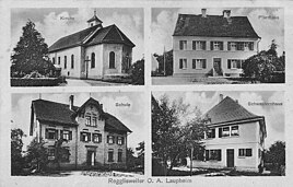
Postcard from Regglisweiler (around 1920)
|
|
Regglisweiler is part of the municipality of Dietenheim in the Alb-Donau district in Baden-Württemberg and a state-approved resort. As part of the municipal reform in Baden-Württemberg , the municipality of Regglisweiler was incorporated into Dietenheim on January 1, 1972 with the hamlets of Kreuthöfe and Brandenburg .
The village is located about one and a half kilometers north of Dietenheim and can be reached via highway 260.
history
Regglisweiler is first handed down in 1273 as "Reclinswiler". Ulrich and Albert de Regnolfwiler are mentioned in 1273 as feudal people of the Counts of Brandenburg. Your castle was probably one and a half kilometers northeast of the place, where two moats have been preserved ( Teufelsgraben ).
Regglisweiler belonged to the dominion of Brandenburg and came to Württemberg in 1810 , where it was subordinated to the Oberamt Wiblingen .
See also
Web links
Individual evidence
- ^ Federal Statistical Office (ed.): Historical municipality directory for the Federal Republic of Germany. Name, border and key number changes in municipalities, counties and administrative districts from May 27, 1970 to December 31, 1982 . W. Kohlhammer, Stuttgart / Mainz 1983, ISBN 3-17-003263-1 , p. 457 .

