Gironde department
| Gironde | |
|---|---|
| region | Nouvelle-Aquitaine |
| prefecture | Bordeaux |
| Sub-prefecture (s) |
Arcachon Blaye Langon Lesparre-Médoc Libourne |
| Residents | 1,583,384 (Jan. 1, 2017) |
| Population density | 159 inhabitants per km² |
| surface | 9,973.73 km² |
| Arrondissements | 6th |
| Community associations | 28 |
| Cantons | 33 |
| Communities | 535 |
|
President of the Department Council |
Jean-Luc Gleyze |
| ISO-3166-2 code | FR-33 |
 Location of the Gironde in the region Nouvelle-Aquitaine |
|
The Gironde [ ʒiʀõːd ] is the French department with the atomic number 33. It is in the west of the country in the region Nouvelle-Aquitaine and is named after the estuary Gironde , who in the department by the confluence of the Dordogne and the Garonne arises named.
geography
The department is located in the north of the Nouvelle-Aquitaine region and, with an area of 9,975 km², forms the second largest French department after French Guiana . The west-east extension is 120 kilometers and the north-south extension 170 kilometers.
The department borders the Atlantic Ocean to the west, the Gironde estuary to the north and the Charente-Maritime department . In the east it borders on the Dordogne department , in the southeast on the Lot-et-Garonne department and in the south on the Landes department .
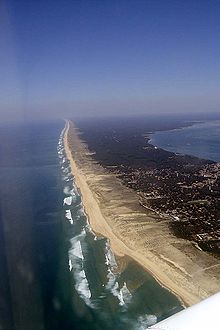
The most important rivers are the Dordogne , which crosses the department from the east, and the Garonne , which flows from the southeast . Both waters join behind the capital Bordeaux to form the Gironde . The Atlantic coast is marked by the estuary of the Gironde in the north, just a few kilometers inland lying lakes of Hourtin-Carcans and Lacanau , the Bay of Arcachon in the south, and the south lying on their sea opening dune of Pilat . The northern part of the coastal area in the triangle between the Gironde estuary, Arcachon Bay and Bordeaux forms the Médoc peninsula . In the west of the department, the pine forests of the Landes de Gascogne extend .
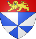
coat of arms
Description : Under a red shield head with a gold running, blue-armored and tongued lion, there is an eight-fold blue-silver stand .
history
The department was formed during the French Revolution on March 4, 1790 from parts of the provinces of Guyenne and Gascogne (mainly the Bordelais and the western part of the Bazadais ). It was divided into seven districts ( French district ), the precursors of the arrondissements : Bazas , Blaye, Bordeaux, Cadillac, Lesparre, Libourne and La Reole. The department and the districts were subdivided into cantons and in 1791 had about 490,000 [?] Inhabitants. The capital was already Bordeaux .
From June 1793 to April 14, 1795, the department was called Bec-d'Ambès.
The arrondissements were built on February 17, 1800. They were Bazas, Blaye , Bordeaux , Lesparre, Libourne and La Reole.
On September 10, 1926, Bazas was replaced by Langon and the arrondissements of Lesparre (to Bordeaux) and La Reole (to Langon) dissolved.
On June 1, 1942, the Lesparre-Médoc arrondissement was rebuilt. From 1944, the German spoke Navy in Gironde-Nord, a Navy hospital that the fortress hospital was expanded.
On January 1, 2007, the Arcachon arrondissement was newly formed with four cantons spun off from the Bordeaux arrondissement.
From 1960 to 2015 it belonged to the Aquitaine region , which in 2016 became part of the Nouvelle Aquitaine region.
Cities
The most populous communes in the Gironde department are:
| city | Population (2017) |
Arrondissement |
|---|---|---|
| Bordeaux | 254,436 | Bordeaux |
| Mérignac | 70.105 | Bordeaux |
| Pessac | 63,808 | Bordeaux |
| Talence | 42,606 | Bordeaux |
| Villenave-d'Ornon | 34,090 | Bordeaux |
| Saint-Médard-en-Jalles | 31,145 | Bordeaux |
| Bègles | 28,601 | Bordeaux |
| La Teste-de-Buch | 26,078 | Arcachon |
| Gradignan | 25,552 | Bordeaux |
| Libourne | 24,845 | Libourne |
Administrative division
The Gironde department is divided into 6 arrondissements , 33 cantons and 538 communes :
| Arrondissement | Cantons | Communities | Residents January 1, 2017 |
Area km² |
Density of population / km² |
Code INSEE |
|---|---|---|---|---|---|---|
| Arcachon | 4th | 17th | 153.033 | 1,469.79 | 104 | 336 |
| Blaye | 2 | 62 | 90,945 | 781.86 | 116 | 331 |
| Bordeaux | 21st | 82 | 961.709 | 1,521.72 | 632 | 332 |
| Langon | 4th | 196 | 132.915 | 2,643.59 | 50 | 333 |
| Lesparre-Médoc | 2 | 49 | 90,339 | 2,273.90 | 40 | 334 |
| Libourne | 5 | 129 | 154,443 | 1,282.87 | 120 | 335 |
| Gironde department | 33 | 535 | 1,583,384 | 9,973.73 | 159 | 33 |
See also:
- List of communes in the Gironde department
- List of cantons in the Gironde department
- List of associations of municipalities in the Gironde department
climate
The maritime climate is decisive for the Gironde department: mild winters (between 5 and 7 ° C) and tolerable summer temperatures (19-21 ° C) with rain that is distributed over all seasons (drizzle), with the highest rainfall being measured during winter .
Bordeaux has an average annual rainfall of 820 mm, Lacanau of 935 mm and Coutras inland of 768 mm. The amount of precipitation is highest in the area covered by forest.
The winds come from the southwest or northwest.
The sunshine is particularly intense along the coast, at the Gironde estuary and the Arcachon basin.
Monitoring station: Cap-Ferret on the Bassin d'Arcachon, 700 meters from the sea
| maritime climate data | J | F. | M. | A. | M. | J | J | A. | S. | O | N | D. |
|---|---|---|---|---|---|---|---|---|---|---|---|---|
| mean maximum temperature | 10 | 11 | 14th | 16 | 19th | 22nd | 25th | 25th | 23 | 19th | 14th | 11 |
| mean low temperature | 4th | 5 | 6th | 8th | 11 | 14th | 16 | 16 | 15th | 11 | 7th | 5 |
| Number of very sunny days | 3 | 3.5 | 5 | 4th | 4th | 5 | 7th | 6th | 6th | 5 | 3 | 2.5 |
| Number of days with an overcast sky | 16 | 13 | 12 | 9 | 10 | 7th | 6th | 6th | 8th | 9 | 14th | 17th |
| Number of rainy days | 13 | 12 | 11 | 9 | 10 | 7th | 7th | 9 | 10 | 10 | 12 | 13 |
| Rainfall in mm | 90 | 75 | 70 | 55 | 65 | 50 | 35 | 60 | 80 | 85 | 90 | 100 |
| Water temperature near the coast | 12 | 11 | 12 | 13 | 15th | 18th | 20th | 21st | 20th | 18th | 16 | 13 |
Days per year with
- Rainfalls over 1 mm: 123
- Frost: 15
- First frost: early December
- Last frost: early March
- Snow: 2
- Thunderstorm: 18
- Hail: 3
As of 1991
Web links
- Gironde department (French)
- Prefecture of the Gironde department (French)
- Statistics on the Gironde department
Individual evidence
- ↑ gironde.fr ( Memento of the original from May 11, 2015 in the Internet Archive ) Info: The archive link has been inserted automatically and has not yet been checked. Please check the original and archive link according to the instructions and then remove this notice. on May 5, 2015.
- ↑ Climate data from: Jean-Noël Darde: Plages et côtes de France. Éditions Balland, Paris 1991.
Coordinates: 44 ° 52 ′ N , 0 ° 33 ′ W


