Gironde (estuary)
| Gironde | ||
|
Location of the Gironde |
||
| Data | ||
| location | France , Nouvelle-Aquitaine region | |
| origin | Confluence of the Garonne and Dordogne at the Bec d ' Ambès , near Bordeaux 45 ° 2 ′ 31 ″ N , 0 ° 36 ′ 26 ″ W |
|
| Source height | approx. 4 m | |
| muzzle | at Royan in the Atlantic Ocean Coordinates: 45 ° 35 '23 " N , 1 ° 2' 57" W 45 ° 35 '23 " N , 1 ° 2' 57" W |
|
| Mouth height | 0 m | |
| Height difference | approx. 4 m | |
| Bottom slope | approx. 0.05 ‰ | |
| length | approx. 75 km (see individual certificates) | |
| Small towns | Pauillac , Saint-Georges-de-Didonne , Royan | |
| Navigable | Yes | |
|
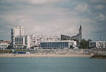
The Gironde estuary seen from the right bank |
||
The Gironde is an estuary in southwest France that stretches from the confluence of the Garonne and Dordogne rivers to the transition to the Atlantic Ocean in the Bay of Biscay . It is 75 kilometers long, up to 15 kilometers wide and runs in a north-northwest direction. With a surface of 685 km² it is the largest estuary in Europe . The Gironde department, which is largely located on the left bank, is named after the Gironde ; Opposite it on the right bank lies the Charente-Maritime department .
geography
Location and course
The Gironde begins on the Bec d ' Ambès , a peninsula about 15 kilometers downstream from Bordeaux , the Garonne and Dordogne form immediately before their confluence. The Médoc wine-growing region stretches along the entire length of the left bank , a low-lying, gently sloping landscape with sedimentary subsoil (gravel and gravel), which is ideally suited for viticulture due to its permeability. The best locations are those that “see the water”, i. H. lie within the special microclimate created by the Gironde: The light is reflected by the large water surface and heat is stored, so that the conditions for the grapes to ripen are optimal. The top wines of the Margaux , Pauillac , Saint-Estèphe , Saint-Julien and a few others are found in these locations . The right bank is initially dominated by a steep limestone step (the Haute Gironde) on which the appellations Côtes de Bourg and Côtes de Blaye lie. In the Charente-Maritime area, the terrain is slowly becoming flatter and viticulture is disappearing. The mouth of the Gironde is marked by the promontory at Le Verdon-sur-Mer , the Pointe de Grave.
The course of the estuary rivers has repeatedly changed slightly over time. The place Bourg-sur-Gironde is today on the Dordogne, because the different levels of sediment transport over the centuries has shifted the course of sandbanks and islands and the Dordogne swerved north before flowing into the Gironde.
Catchment area and borders
The Gironde catchment area includes those of the two rivers that feed it: the Dordogne drains the northern Guyenne and a large part of the south-western Massif Central , the Garonne almost the entire rest of the Aquitaine basin. With the exception of the Basque Country and the coastal areas of the Landes , this includes a catchment area that is bounded by the Pyrenees in the south, the watershed to the Mediterranean Sea in the east and the main watershed of the Massif Central in the north and north-east and encompasses almost a fifth of all of France. The freshwater runoff is, however, exceeded by 15 to 30 times the volume of seawater flowing in at high tide.
The demarcation of the Gironde is controversial: In addition to the water surface from the Bec d'Ambès, many also include the lower reaches of the Garonne and Dordogne, as salinity and tidal range are still clearly manifest here. The considerable width of the two rivers also means that the landscape between them is called Entre deux mers (between two seas). The adjacent banks are also often counted as part of the estuary, especially the swampy lowlands on the left bank. The estuary itself is divided into an upper section (with numerous islands) and a lower section.
climate
The Gironde is located in the temperate climate zone of oceanic character ( maritime climate ) with very mild winters, warm summers and frequent rainfall. Due to the enormous water surface, it mitigates the climate effects in the surrounding area again, so that there is a very even temperature curve here. The winters are often frost-free, the summers are still very bearable. The last ice drift on the Gironde was recorded in the record winter of 1956.
traffic
Since the Gironde, due to its enormous breadth, is a traffic obstacle, especially in the estuary, and there are no bridges to overcome it, two car ferry connections were established. They connect the places:
- Blaye - Lamarque and
- Royan - Le Verdon-sur-Mer .
Cities

If you add the lower reaches of the estuary rivers, Bordeaux and its agglomeration are the dominant city of the Gironde. Inland on the Dordogne lies Libourne , the other historically significant river port, which today only plays a subordinate role compared to Bordeaux. On the Gironde itself, the seaside resort of Royan (Charente-Maritime) is the most important settlement with just under 20,000 inhabitants (80,000 in the agglomeration). Well-known towns and villages are on the right bank Blaye , Bourg and Talmont , on the left bank Blanquefort , Pauillac and Margaux .
Ecosystem

Like many brackish water reservoirs, the Gironde is a species-poor, but rich in individuals body of water. This has made it a rich fishing ground in all ages. The individual species vary depending on the salinity of the surrounding water.
The basis of the food chain is the phytoplankton , which does not occur in the middle reaches due to the turbulence during the tides, and the zooplankton , which is mainly formed by millimeter-sized cancers. White crabs are more numerous than anywhere else in France. The fish species are either marine fish, which can swim inland up to a certain point, or migratory species that are adapted to fresh and salt water. The former include sole , ray and anchovy , the latter include eel , alse and lamprey .
The Gironde is home to the European sturgeon , which has its last refuge in the world here. It has been under nature protection since 1982, when the species was almost extinct, and has been specifically bred and released since then. For some time now, caviar has even been extracted again on a modest scale .
Since it is on the migratory route of many migratory birds , the area is also a preferred breeding and resting place for around 130 bird species. Here you can find the cormorant , the black-headed gull and the white stork as native species, as well as periodically ducks , buzzards and many more.
The Gironde ecosystem is very fragile due to the muddy subsoil, because it absorbs significantly more pollutants than other soils. In particular, the entry of zinc and cadmium has led to oysters growing in the wild no longer being allowed to be consumed due to the accumulation of heavy metals in their meat. Exotics also pose a certain problem, as they can impair the original fauna through release or introduction. A particularly illustrious example of this is a piranha caught in the Gironde in 2004.
The Gironde has been part of the Estuaire de la Gironde et Mer des Pertuis Marine Nature Park since 2015 .
history
The Gironde played an outstanding strategic and economic role as early as the Bronze Age , at least since the Roman Age . Bordeaux, the then Burdigala, already had a seaport that was accessible via the Gironde and laid the foundation for trade and long-term prosperity. Roman remains, as well as a Gallic boar standard, have been found in Soulac-sur-Mer . The floor plans of patrician villas lead to the conclusion that there must have been a summer retreat right at the Gironde estuary, where the rich citizens of Burdigala went. The incursions of the Normans , who invaded the Gironde after the fall of the Roman Empire and devastated Bordeaux , showed that strategically important access to the sea also has disadvantages .
In the late Middle Ages, the area was in English hands: trade between Aquitaine and the British Isles was carried out via the Gironde. Bordeaux exported the wine cultivated in the region in particular, which was called claret in England and was very much appreciated. Export items also included dyes, salt and weapons. Stockfish, leather, fabrics and metals were imported from England. The shipping route was not only important from a commercial point of view: it was also used to move most of the troop contingents that were provided by the British during the Hundred Years' War . Due to the conflict between England and France, but also by pirates , sea trade was repeatedly disrupted, so that at times powerful naval units were formed to protect each other.

In the early modern period, when the French regained control of the territory, Bordeaux was the nation's largest and most important port, through which much of the Atlantic sea trade with Africa and the Antilles was conducted. The Gironde was therefore of paramount strategic importance and was specifically provided with fortifications and garrison sites. In the 17th century Vauban built the large fortress Blaye on the right bank, which received a - less spectacular - counterpart, Fort Médoc on the left bank. An additional post was set up on an island so that the Gironde could not be navigated without permission or military conflict. This precaution also secured the economic concept of mercantilism in terms of military strategy.
In June 1940 the Wehrmacht conquered large parts of France (" Western Campaign "). Hitler ordered the construction of the Atlantic Wall , the southern end of which was the Garonne. In the "Fuehrer's Instruction No. 50" Hitler ordered that all river estuaries be developed into strong "defensive areas" in order to secure them against an Allied invasion. In January 1944, Hitler declared some areas of defense to be “fortresses” that had to be defended “down to the last cartridge” (see Fester Platz (Wehrmacht) ). On the headland between the Atlantic Ocean and the Gironde, the Gironde South Fortress was built on an area of 170 square kilometers .
In the 20th century, when the city port of Bordeaux was gradually abandoned, the Gironde gained particular economic importance. A large part of the cargo handling was relocated downstream, among other things the special needs of the handling of ocean liners had to be taken into account, which could not go up to the Garonne. Therefore, a container terminal was set up in Le Verdon , which could also take over the oil loading. A refinery was built in Pauillac between Le Verdon and Bordeaux. This has led to a certain degree of industrialization along the Gironde.
Web links
Individual evidence
- ↑ a b geoportail.fr (1: 16,000)
- ↑ The Gironde is not included in the French water database sandre.fr , because according to the logic there it is already counted as an estuary in the sea. The information about the dimensions of the Gironde was therefore taken from fr.wiki .


