Cher department
| Cher | |
|---|---|
| region | Center-Val de Loire |
| prefecture | Bourges |
| Sub-prefecture (s) |
Saint-Amand-Montrond Vierzon |
| Residents | 304,256 (Jan. 1, 2017) |
| Population density | 42 inhabitants per km² |
| surface | 7,234.95 km² |
| Arrondissements | 3 |
| Community associations | 19th |
| Cantons | 19th |
| Communities | 287 |
|
President of the Department Council |
Michel Autissier |
| ISO-3166-2 code | FR-18 |
 Location of the department of Cher in the region Center-Val de Loire |
|
The Cher [ ʃɛːʀ ] is the French department of 18 with the ordinal number It is located in the center of the country in the Region Center-Val de Loire and is named after the river Cher named.
geography
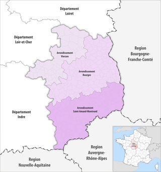
The Cher department borders on the Indre and Loir-et-Cher departments in the west, the Loiret department in the north, the Nièvre department in the east, the Allier department in the south-east and the Creuse department in the extreme south .
While the Loire forms the eastern border to the Nièvre department, the eponymous Cher flows through the west of the department in a northerly direction.
history
The department was formed on March 4, 1790 mainly from the eastern part of the Berry province and the northeast of the Bourbonnais .
It has belonged to the Center region since 1960 , which was renamed Center-Val de Loire in 2016 .
coat of arms
The blazon for the coat of arms of the Cher department reads in French:
d'azur semé de fleurs de lys d'or, à la bordure engrêlée cousue de gueules, à la fasce ondée d'argent brochant sur le tout (blue, studded with golden lilies, with a red, curved hem, over everything a silver wave bar .)
This coat of arms is originally the coat of arms of John of France , Duke of Berry since 1360, third son of John the Good .
The overlaid wave bar represents the river Cher .
The original design for today's coat of arms including its blazon was created by Robert Louis in the 1950s.
Cities
The most populous communes of the Cher department are:
| city | Population (2017) |
Arrondissement |
|---|---|---|
| Bourges | 64,551 | Bourges |
| Vierzon | 25.903 | Vierzon |
| Saint-Amand-Montrond | 9,437 | Saint-Amand-Montrond |
| Saint-Doulchard | 9,505 | Bourges |
| Saint-Florent-sur-Cher | 6,537 | Bourges |
| Mehun-sur-Yèvre | 6,562 | Vierzon |
| Aubigny-sur-Nère | 5,488 | Vierzon |
| Saint-Germain-du-Puy | 5,085 | Bourges |
Administrative division
The Cher département is divided into three arrondissements , 19 cantons and 287 communes :
| Arrondissement | Cantons | Communities | Residents January 1, 2017 |
Area km² |
Density of population / km² |
Code INSEE |
|---|---|---|---|---|---|---|
| Bourges | 11 | 128 | 171,849 | 2,783.87 | 62 | 181 |
| Saint-Amand-Montrond | 5 | 116 | 62,977 | 2,683.72 | 23 | 182 |
| Vierzon | 5 | 43 | 69,430 | 1,767.36 | 39 | 183 |
| Cher department | 19th | 287 | 304.256 | 7,234.95 | 42 | 18th |
See also:
- List of communes in the Cher department
- List of cantons in the Cher department
- List of associations of municipalities in the Cher department
Web links
- Cher (French)
- Prefecture of the Cher department (French)
Individual evidence
Coordinates: 47 ° 5 ' N , 2 ° 27' E


