
Saint-Florent-sur-Cher
| Saint-Florent-sur-Cher | ||
|---|---|---|
.svg)
|
|
|
| region | Center-Val de Loire | |
| Department | Cher | |
| Arrondissement | Bourges | |
| Canton | Chârost | |
| Community association | Fercher Pays Florentais | |
| Coordinates | 47 ° 0 ′ N , 2 ° 15 ′ E | |
| height | 117-164 m | |
| surface | 22.41 km 2 | |
| Residents | 6,537 (January 1, 2017) | |
| Population density | 292 inhabitants / km 2 | |
| Post Code | 18400 | |
| INSEE code | 18207 | |
| Website | www.ville-saint-florent-sur-cher.fr | |
 lock |
||

Saint-Florent-sur-Cher is a commune with 6537 inhabitants (at January 1, 2017) in the department of Cher in the region Center-Val de Loire . It belongs to the Arrondissement of Bourges and the Canton of Chârost .
geography
The municipality is located around 15 kilometers southwest of Bourges . Neighboring communities are:
- Villeneuve-sur-Cher in the north,
- Morthomiers in the northeast,
- Le Subdray in the east,
- Saint-Caprais in the southeast,
- Lunery in the south and
- Civray to the west.
The municipality capital is crossed by the river Cher in a south-north direction , in the western municipality area the Arnon runs parallel to it .
Transport links
The railway company Compagnie du chemin de fer de Paris à Oréans opened the local train station on December 9, 1861 . This is now served by the SNCF and the TER Center and is part of the Bourges - Montluçon railway line of the Réseau ferré de France .
Population development
| year | 1968 | 1975 | 1982 | 1990 | 1999 | 2006 | 2012 |
| Residents | 6,408 | 6,535 | 7,611 | 7,358 | 6,900 | 6,756 | 6,617 |
Attractions
- 15th century castle - Monument historique
Partner communities
literature
- Le Patrimoine des Communes du Cher. Flohic Editions, Volume 1, Paris 2001, ISBN 2-84234-088-4 , pp. 299-302.
Web links

Castle with the city administration (Mairie)

Bridge built in Saint-Florent-sur-Cher in 1893/93
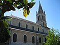
Saint Florent Church from the 19th century

Saint-Florent-sur-Cher train station


Individual evidence
- ↑ Château de Saint-Florent in the Base Mérimée of the French Ministry of Culture (French)