
Saint-Doulchard
| Saint-Doulchard | ||
|---|---|---|
|
||
| region | Center-Val de Loire | |
| Department | Cher | |
| Arrondissement | Bourges | |
| Canton | Saint-Doulchard (main town) | |
| Community association | Bourges Plus | |
| Coordinates | 47 ° 6 ′ N , 2 ° 21 ′ E | |
| height | 119-167 m | |
| surface | 24.01 km 2 | |
| Residents | 9,505 (January 1, 2017) | |
| Population density | 396 inhabitants / km 2 | |
| Post Code | 18230 | |
| INSEE code | 18205 | |
| Website | www.mairie-saintdoulchard.fr | |
 Town Hall ( Hôtel de ville ) |
||

Saint-Doulchard is a commune with 9505 inhabitants (at January 1, 2017) in the department of Cher in the region Center-Val de Loire . It belongs to the Arrondissement of Bourges and the canton of Saint-Doulchard , of which it is the chief town (Chef-lieu). The inhabitants call themselves Dolchardiens .
geography
The municipality is located in the agglomeration north-west of Bourges . Neighboring communities are:
- Saint-Éloy-de-Gy in the north,
- Vasselay in the northeast,
- Bourges to the east and south,
- La Chapelle-Saint-Ursin in the southwest, and
- Berry-Bouy to the west.
Transport links
From the city of Bourges, the département road D2076 leads in a northerly direction , which turns north-west in the municipality towards Vierzon , while the D944 continues north. At the western border of the municipality, the D400 runs as the western bypass of Bourges. The railway line from Réseau ferré de France to Bourges is on the southern border.
history
According to a mention of the village from 1065, it was then called "Sanctus Dulcardus". In Saint-Doulchard the order of the Annunti women was founded.
Population development
| year | 1968 | 1975 | 1982 | 1990 | 1999 | 2006 | 2012 |
| Residents | 5274 | 6609 | 7928 | 9149 | 9018 | 9020 | 9242 |

Saint-Doulchard church
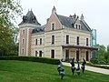
Château de Vayre


Personalities
- Bernard Diomède (born 1974), football player
- William Bonnet (* 1982), racing cyclist
- Vincent Graczyk (* 1984), football player
- François Goeske (* 1989), German-French film actor and voice actor
- Charlotte Bilbault (1990), soccer player
- Baptiste Santamaria (* 1995), football player
literature
- Le Patrimoine des Communes du Cher. Flohic Editions, Volume 2, Paris 2001, ISBN 2-84234-088-4 , pp. 781-783.