Henrichemont
| Henrichemont | ||
|---|---|---|

|
|
|
| region | Center-Val de Loire | |
| Department | Cher | |
| Arrondissement | Bourges | |
| Canton | Saint-Germain-du-Puy | |
| Community association | Terres du Haut Berry | |
| Coordinates | 47 ° 18 ' N , 2 ° 32' E | |
| height | 217-390 m | |
| surface | 25.27 km 2 | |
| Residents | 1,760 (January 1, 2017) | |
| Population density | 70 inhabitants / km 2 | |
| Post Code | 18250 | |
| INSEE code | 18109 | |
| Website | www.henrichemont.fr | |
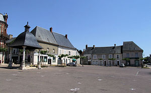
 Henrichemont town center |
||
Henrichemont is a French commune with 1,760 inhabitants (as of January 1, 2017) in the Cher department in the Center-Val de Loire region . The municipality belongs to the Arrondissement of Bourges and the canton of Saint-Germain-du-Puy (until 2015: canton of Henrichemont ).
geography
Henrichemont is about 26 kilometers north-northeast of Bourges . Henrichemont is surrounded by the neighboring communities Ivoy-le-Pré in the north and north-west, La Chapelotte in the east and north-east, Humbligny in the east and south-east, Morogues in the south-east, Parassy in the south, Menetou-Salon in the south-west and Achères in the west and south-west.
A military radio station is located here .
history
Henrichemont was founded in 1609 by Maximilien von Béthune, Duke of Sully. Previously there was only the village of Boisbelle here . A sovereign principality of Henrichemont existed until the late 17th century.
Population development
| 1962 | 1968 | 1975 | 1982 | 1990 | 1999 | 2006 | 2012 |
|---|---|---|---|---|---|---|---|
| 2.137 | 1,973 | 1,894 | 1,826 | 1,845 | 1,829 | 1,813 | 1,797 |
| Source: Cassini and INSEE | |||||||
Attractions
- Saint-Laurent church from the 19th century
- Hill fort (moth)
- Pottery museums and potters in La Bourne
- Old coin
- House Sully, Monument historique
literature
- Le Patrimoine des Communes du Cher. Flohic Editions, Volume 1, Paris 2001, ISBN 2-84234-088-4 , pp. 505-514.
