Lugny-Champagne
| Lugny-Champagne | ||
|---|---|---|
|
|
||
| region | Center-Val de Loire | |
| Department | Cher | |
| Arrondissement | Bourges | |
| Canton | Avord | |
| Community association | Berry-Loire-Vauvise | |
| Coordinates | 47 ° 11 ′ N , 2 ° 49 ′ E | |
| height | 162-204 m | |
| surface | 29.54 km 2 | |
| Residents | 142 (January 1, 2017) | |
| Population density | 5 inhabitants / km 2 | |
| Post Code | 18140 | |
| INSEE code | 18132 | |
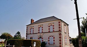
 Town hall (Mairie) of Lugny-Champagne |
||
Lugny-Champagne is a French municipality with 142 inhabitants (as of January 1 2017) in the department of Cher in the region Center-Val de Loire . It belongs to the canton of Avord (until 2015: canton of Sancergues ) and to the communal association Communauté de communes Berry-Loire-Vauvise . The inhabitants are called Étréchyssois .
geography
Lugny-Champagne is located in the Berry about 34 kilometers east-northeast of Bourges . Lugny-Champagne is surrounded by the neighboring communities of Groises in the north and north-west, Feux in the north-east, Sancerques in the east, Charentonnay in the east and south-east, Sévry in the south, Chamoux-Marcilly in the south-west and Étréchy in the west and south-west.
population
| year | 1793 | 1800 | 1872 | 1906 | 1931 | 1936 | 1946 | 1954 | 1962 | 1968 | 1975 | 1982 | 1990 | 1999 | 2006 | 2013 |
|---|---|---|---|---|---|---|---|---|---|---|---|---|---|---|---|---|
| Residents | 505 | 490 | 533 | 472 | 409 | 386 | 372 | 341 | 360 | 321 | 275 | 221 | 207 | 166 | 177 | 149 |
Attractions
- Saint-Fiacre church from the 13th century, first mentioned in 1139
literature
- Le Patrimoine des Communes du Cher. Flohic Editions, Volume 2, Paris 2001, ISBN 2-84234-088-4 , p. 847.
Web links
Commons : Lugny-Champagne - Collection of images, videos and audio files

