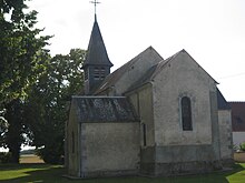
Plou
| Plou | ||
|---|---|---|
|
|
||
| region | Center-Val de Loire | |
| Department | Cher | |
| Arrondissement | Bourges | |
| Canton | Chârost | |
| Community association | Fercher Pays Florentais | |
| Coordinates | 47 ° 1 ' N , 2 ° 9' E | |
| height | 122-166 m | |
| surface | 33.21 km 2 | |
| Residents | 529 (January 1, 2017) | |
| Population density | 16 inhabitants / km 2 | |
| Post Code | 18290 | |
| INSEE code | 18181 | |
 Castelnau Castle |
||
Plou is a commune with 529 inhabitants (as of January 1 2017) in the department of Cher in the region Center-Val de Loire . It belongs to the Arrondissement of Bourges and the Canton of Chârost .
geography
Plou is about 20 kilometers southwest of Bourges . Plou is surrounded by the neighboring communities of Limeux in the north and northwest, Preuilly in the north, Sainte-Thourette in the northeast, Villeneuve-sur-Cher in the east, Civray in the south and southeast, Chârost in the south, Saint-Georges-sur-Arnon in the southwest, Poisieux in the west and Lazenay in the northwest.
Population development
| year | 1962 | 1968 | 1975 | 1982 | 1990 | 1999 | 2006 | 2013 |
| Residents | 478 | 421 | 469 | 410 | 436 | 436 | 455 | 525 |
| Source: Cassini and INSEE | ||||||||
Attractions
- Saint-Pierre church, originally from the 11th century, today's construction mainly from the 13th century
- Castelnau Castle in Brouillamnon, before the 12th century a wooden hill fort, then a castle fortress, converted into a castle in 1541, today's building from 1841
- Castle ruins in Font-Moreau from the 14th century
Personalities
- Jacques de Castelnau-Bochetel (1620–1658), marquis de Castelnau, Marshal of France
- Théophile Marion Dumersan (1780–1849), poet
literature
- Le Patrimoine des Communes du Cher. Flohic Editions, Volume 1, Paris 2001, ISBN 2-84234-088-4 , pp. 290-291.
Web links
Commons : Plou - collection of images, videos and audio files

