
Limeux (Cher)
| Limeux | ||
|---|---|---|
|
||
| region | Center-Val de Loire | |
| Department | Cher | |
| Arrondissement | Vierzon | |
| Canton | Mehun-sur-Yèvre | |
| Community association | Coeur de Berry | |
| Coordinates | 47 ° 5 ' N , 2 ° 7' E | |
| height | 127-149 m | |
| surface | 13.17 km 2 | |
| Residents | 162 (January 1, 2017) | |
| Population density | 12 inhabitants / km 2 | |
| Post Code | 18120 | |
| INSEE code | 18128 | |
 Town hall (Mairie) of Limeux |
||

Limeux is a French municipality with 162 inhabitants (as of January 1 2017) in the department of Cher in the region Center-Val de Loire ; it belongs to the Arrondissement Vierzon and the canton Mehun-sur-Yèvre (until 2015: canton Lury-sur-Arnon ).
geography
Limeux is about 21 kilometers west of Bourges and about 16 kilometers south-southeast of Vierzon . Limeux is surrounded by the neighboring communities of Cerbois in the north, Preuilly in the east and northeast, Plou in the south and southeast and Lazenay in the south and west.
Population development
| year | 1962 | 1968 | 1975 | 1982 | 1990 | 1999 | 2006 | 2013 |
| Residents | 169 | 163 | 144 | 133 | 158 | 145 | 148 | 156 |
| Source: Cassini and INSEE | ||||||||
Attractions
- Saint-Martin church from the 11th century
- Saragosse Castle from the 14th century, renovations from the 17th century, historic monument since 1997
- Saint-Laurent priory church in Manzay, monument historique since 1926
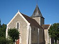
Saint Martin Church
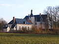
Saragosse Castle


literature
- Le Patrimoine des Communes du Cher. Flohic Editions, Volume 2, Paris 2001, ISBN 2-84234-088-4 , pp. 659-660.
Web links
Commons : Limeux - collection of images, videos and audio files