
Méry-sur-Cher
| Méry-sur-Cher | ||
|---|---|---|
.svg)
|
|
|
| region | Center-Val de Loire | |
| Department | Cher | |
| Arrondissement | Vierzon | |
| Canton | Vierzon-2 | |
| Community association | Vierzon-Sologne-Berry | |
| Coordinates | 47 ° 15 ′ N , 1 ° 59 ′ E | |
| height | 93-158 m | |
| surface | 20.91 km 2 | |
| Residents | 678 (January 1, 2017) | |
| Population density | 32 inhabitants / km 2 | |
| Post Code | 18100 | |
| INSEE code | 18150 | |
| Website | www.mery-sur-cher.fr | |

Méry-sur-Cher is a French commune with a population of 678 (as at 1st January 2017) in the department of Cher in the region Center-Val de Loire ; it belongs to the Arrondissement Vierzon and the canton Vierzon-2 .
geography
Méry-sur-Cher is located about three kilometers west-northwest of the city center of Vierzon on the Canal de Berry . The Cher borders the community in the south. Méry-sur-Cher is surrounded by the neighboring communities Theillay in the north and northeast, Vierzon in the east and southeast, Saint-Hilaire-de-Court in the south and southeast, Saint-Georges-sur-la-Prée in the south and southwest and Thénioux in the West.
Population development
| year | 1962 | 1968 | 1975 | 1982 | 1990 | 1999 | 2006 | 2012 |
| Residents | 540 | 515 | 534 | 555 | 601 | 625 | 674 | 680 |
| Source: Cassini and INSEE | ||||||||
Attractions
- Saint Martin Church
- Méry Castle from the 16th century
- La Forêt castle from the 17th century
- Gaillard Palace from the 19th century
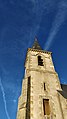
Tower of the Saint-Martin church

Personalities
- Cyprian Godebski (1835-1909); Sculptor, cyclist
literature
- Le Patrimoine des Communes du Cher. Flohic Editions, Volume 2, Paris 2001, ISBN 2-84234-088-4 , pp. 1030-1032.
Web links
Commons : Méry-sur-Cher - Collection of images, videos and audio files