
Lazenay
| Lazenay | ||
|---|---|---|
|
||
| region | Center-Val de Loire | |
| Department | Cher | |
| Arrondissement | Vierzon | |
| Canton | Mehun-sur-Yèvre | |
| Community association | Coeur de Berry | |
| Coordinates | 47 ° 4 ′ N , 2 ° 4 ′ E | |
| height | 107-153 m | |
| surface | 30.74 km 2 | |
| Residents | 342 (January 1, 2017) | |
| Population density | 11 inhabitants / km 2 | |
| Post Code | 18120 | |
| INSEE code | 18124 | |
 Lazenay Town Hall (Mairie) |
||

Lazenay is a French municipality with 342 inhabitants (as of January 1 2017) in the department of Cher in the region Center-Val de Loire ; it belongs to the Arrondissement Vierzon and the canton Mehun-sur-Yèvre (until 2015: canton Lury-sur-Arnon ).
geography
Lazenay is located about 25 kilometers west of Bourges and about 16 kilometers south of Vierzon on the banks of the River Arnon . Lazenay is surrounded by the neighboring communities of Lury-sur-Arnon in the north, Cerbois in the east and northeast, Limeux in the east, Plou in the southeast, Poisieux and Migny in the south, Diou in the southwest, Reuilly in the west and Chéry in the northwest.
Population development
| year | 1962 | 1968 | 1975 | 1982 | 1990 | 1999 | 2006 | 2013 |
| Residents | 387 | 413 | 337 | 300 | 326 | 354 | 352 | 350 |
| Source: Cassini and INSEE | ||||||||
Attractions
- Notre-Dame church from the 11th / 12th centuries century
- Lazenay Castle from the middle of the 19th century
- La Ferté Castle

Notre-Dame church
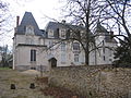
Lazenay Castle


literature
- Le Patrimoine des Communes du Cher. Flohic Editions, Volume 2, Paris 2001, ISBN 2-84234-088-4 , pp. 657-658.
Web links
Commons : Lazenay - collection of images, videos and audio files