
Cerbois
| Cerbois | ||
|---|---|---|
.svg)
|
|
|
| region | Center-Val de Loire | |
| Department | Cher | |
| Arrondissement | Vierzon | |
| Canton | Mehun-sur-Yèvre | |
| Community association | Coeur de Berry | |
| Coordinates | 47 ° 7 ' N , 2 ° 6' E | |
| height | 118-142 m | |
| surface | 18.45 km 2 | |
| Residents | 435 (January 1, 2017) | |
| Population density | 24 inhabitants / km 2 | |
| Post Code | 18120 | |
| INSEE code | 18044 | |
 Town hall (Mairie) of Cerbois |
||

Cerbois is a commune with 435 inhabitants (as of January 1, 2017) in the department of Cher in the region Center-Val de Loire ; it belongs to the Arrondissement Vierzon and the canton Mehun-sur-Yèvre (until 2015: canton Lury-sur-Arnon ).
geography
Cerbois is located about 22 kilometers west-northwest of Bourges and about eleven kilometers south-southeast of Vierzon . Cerbois is surrounded by the neighboring communities of Brinay in the north, Quincy in the east and northeast, Preuilly in the southeast, Limeux in the south, Lazenay in the west and southwest and Lury-sur-Arnon in the west and northwest.
Population development
| year | 1962 | 1968 | 1975 | 1982 | 1990 | 1999 | 2006 | 2013 |
|---|---|---|---|---|---|---|---|---|
| Residents | 314 | 296 | 264 | 253 | 313 | 359 | 419 | 444 |
| Source: Cassini and INSEE | ||||||||
Attractions
- Saint Martin Church
- Castle from the 15th / 16th centuries century
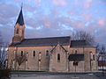
Saint Martin Church
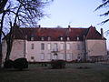
Cerbois Castle


literature
- Le Patrimoine des Communes du Cher. Flohic Editions, Volume 2, Paris 2001, ISBN 2-84234-088-4 , pp. 654-655.
Web links
Commons : Cerbois - collection of images, videos and audio files