
Blancafort (Cher)
| Blancafort | ||
|---|---|---|
.svg)
|
|
|
| region | Center-Val de Loire | |
| Department | Cher | |
| Arrondissement | Vierzon | |
| Canton | Aubigny-sur-Nère | |
| Community association | Sauldre and Sologne | |
| Coordinates | 47 ° 32 ' N , 2 ° 32' E | |
| height | 162-261 m | |
| surface | 64.35 km 2 | |
| Residents | 1,038 (January 1, 2017) | |
| Population density | 16 inhabitants / km 2 | |
| Post Code | 18410 | |
| INSEE code | 18030 | |

Blancafort is a French commune with 1,038 inhabitants (at January 1, 2017) in the department of Cher in the region Center-Val de Loire ; it belongs to the Arrondissement Vierzon and the canton of Aubigny-sur-Nère .
Population development
| year | 1962 | 1968 | 1975 | 1982 | 1990 | 1999 | 2008 | 2012 |
| Residents | 972 | 1007 | 936 | 1070 | 991 | 995 | 1131 | 1142 |
Attractions
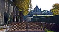
- Blancafort Castle (15th century)
- Saint-Étienne church (15th century)
- Magic Museum (Musée de la sorcellerie)
- Canal de la Sauldre
- Castle l'Hospital-du-Fresne
lock

Beginning of the Canal de la Sauldre in Blancafort

Wash house

.JPG)

literature
- Le Patrimoine des Communes du Cher. Flohic Editions, Volume 1, Paris 2001, ISBN 2-84234-088-4 , pp. 75-77.
Web links
Commons : Blancafort - collection of images, videos and audio files