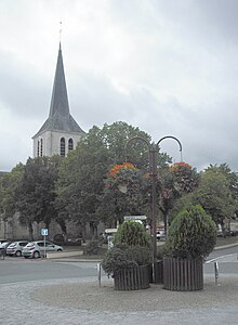
Theillay
| Theillay | ||
|---|---|---|

|
|
|
| region | Center-Val de Loire | |
| Department | Loir-et-Cher | |
| Arrondissement | Romorantin-Lanthenay | |
| Canton | Selles-sur-Cher | |
| Community association | Sologne des Rivières | |
| Coordinates | 47 ° 19 ′ N , 2 ° 2 ′ E | |
| height | 96-168 m | |
| surface | 96.38 km 2 | |
| Residents | 1,260 (January 1, 2017) | |
| Population density | 13 inhabitants / km 2 | |
| Post Code | 41300 | |
| INSEE code | 41256 | |
| Website | http://www.theillay.com/ | |
Theillay is a French commune with 1,260 inhabitants (as of January 1 2017) in Loir-et-Cher in the region Center-Val de Loire ; it belongs to the arrondissement Romorantin-Lanthenay and the canton Selles-sur-Cher (until 2015: canton Salbris ).
geography
Theillay is about 37 kilometers north-west of Bourges am Rère . Theillay is surrounded by the neighboring communities Salbris in the north, Nançay in the east and northeast, Orçay in the east, Vierzon and Méry-sur-Cher in the south, Châtres-sur-Cher in the west and La Ferté-Imbault in the north-west.
The motorway triangle of the Autoroute A71 with that of the Autoroute A85 is located in the municipality .
Population development
| year | 1962 | 1968 | 1975 | 1982 | 1990 | 1999 | 2006 | 2017 |
| Residents | 1332 | 1288 | 1198 | 1245 | 1354 | 1293 | 1267 | 1260 |
| Sources: Cassini and INSEE | ||||||||
history
On July 16, 1918 a passenger train of the Chemin de fer de Paris à Orléans derailed between Theillay and Vierzon . 22 people died, 76 were also injured.
Attractions
- Saint-Sulpice church
- Rère castle from the 14th century
- La Frégeolière castle from the 17th century
Web links
Individual evidence
- ^ Peter WB Semmens: Catastrophes on rails. A worldwide documentation. Transpress, Stuttgart 1996, ISBN 3-344-71030-3 , p. 53.

