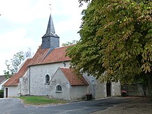
Châtillon-sur-Cher
| Châtillon-sur-Cher | ||
|---|---|---|

|
|
|
| region | Center-Val de Loire | |
| Department | Loir-et-Cher | |
| Arrondissement | Romorantin-Lanthenay | |
| Canton | Saint-Aignan | |
| Community association | Val de Cher-Controis | |
| Coordinates | 47 ° 17 ′ N , 1 ° 30 ′ E | |
| height | 67-118 m | |
| surface | 29.66 km 2 | |
| Residents | 1,722 (January 1, 2017) | |
| Population density | 58 inhabitants / km 2 | |
| Post Code | 41130 | |
| INSEE code | 41043 | |
Châtillon-sur-Cher is a French commune with 1,722 inhabitants (as of January 1 2017) in the department of Loir-et-Cher in the region Center-Val de Loire . It belongs to the Arrondissement Romorantin-Lanthenay and the Canton of Saint-Aignan .
geography
Châtillon-sur-Cher is located on the Cher River and the Berry Canal . Here the Fouzon and the Sauldre flow into the Cher. Châtillon-sur-Cher is surrounded by the neighboring communities of Méhers in the north, Chémery in the north and northeast, Billy in the east and northeast, Selles-sur-Cher in the east, Meusnes in the south, Couffy in the southwest, Noyers-sur-Cher in the west as well Saint-Romain-sur-Cher in the north-west.
Population development
| year | 1962 | 1968 | 1975 | 1982 | 1990 | 1999 | 2006 | 2017 |
| Residents | 1338 | 1333 | 1343 | 1289 | 1395 | 1516 | 1570 | 1722 |
| Sources: Cassini and INSEE | ||||||||
Attractions
- Saint Blaise Church
Web links
Commons : Châtillon-sur-Cher - Collection of images, videos and audio files

