
Mennetou-sur-Cher
| Mennetou-sur-Cher | ||
|---|---|---|
.svg)
|
|
|
| region | Center-Val de Loire | |
| Department | Loir-et-Cher | |
| Arrondissement | Romorantin-Lanthenay | |
| Canton | Selles-sur-Cher | |
| Community association | Romorantinais et du Monestois | |
| Coordinates | 47 ° 16 ′ N , 1 ° 52 ′ E | |
| height | 82-152 m | |
| surface | 16.26 km 2 | |
| Residents | 885 (January 1, 2017) | |
| Population density | 54 inhabitants / km 2 | |
| Post Code | 41320 | |
| INSEE code | 41135 | |
| Website | http://www.mennetou.fr/ | |
 Town hall (Mairie) of Mennetou-sur-Cher |
||

Mennetou-sur-Cher is a French commune with a population of 885 (as at 1st January 2017) in the department of Loir-et-Cher in the region Center-Val de Loire . It belongs to the arrondissement Romorantin-Lanthenay and the canton Selles-sur-Cher (until 2015: canton Mennetou-sur-Cher ). The inhabitants are called Monestois .
geography
Mennetou-sur-Cher is located about 15 kilometers west-northwest of Vierzon am Cher . Mennetou-sur-Cher is surrounded by the neighboring communities Langon-sur-Cher in the north and west, Châtres-sur-Cher in the east, Maray in the south and Saint-Loup in the southwest.
The A85 car route and the former route nationale 76 (today's D976) run through the municipality .
Population development
| 1962 | 1968 | 1975 | 1982 | 1990 | 1999 | 2006 | 2013 |
| 950 | 967 | 984 | 900 | 827 | 903 | 880 | 886 |
| Source: Cassini and INSEE | |||||||
Attractions
- Saint-Urbain church, historic monument since 1920
- old priory
- historical fortification (Monument historique) and historical center
- Bridge over the Cher
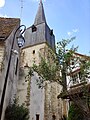
Saint-Urbain church

old priory
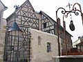
typical half-timbered house in the town center
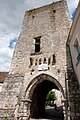
Site fortification

Bridge over the Cher


Personalities
- Michel Breitman (1926–2009), writer