
Saint-Denis-lès-Sens
| Saint-Denis-lès-Sens | ||
|---|---|---|
|
||
| region | Bourgogne-Franche-Comté | |
| Department | Yonne | |
| Arrondissement | Sens | |
| Canton | Thorigny-sur-Oreuse | |
| Community association | Grand Sénonais | |
| Coordinates | 48 ° 13 ' N , 3 ° 13' E | |
| height | 61-75 m | |
| surface | 6.73 km 2 | |
| Residents | 723 (January 1, 2017) | |
| Population density | 107 inhabitants / km 2 | |
| Post Code | 89100 | |
| INSEE code | 89342 | |
 Town hall of Saint-Denis-lès-Sens |
||

Saint-Denis-les-Sens (even by 2012: Saint-Denis ) is a French municipality with 723 inhabitants (as of January 1 2017) in the department of Yonne in the region Bourgogne Franche-Comté . Saint-Denis-lès-Sens belongs to the Arrondissement of Sens and the canton of Thorigny-sur-Oreuse (until 2015: Canton Sens-Ouest ). The inhabitants are called Dionysia .
geography
Saint-Denis-lès-Sens is located about three kilometers north-northwest of the city center of Sens on the Yonne , which borders the municipality to the west. Saint-Denis-lès-Sens is surrounded by the neighboring communities Cuy in the north, Soucy in the east and northeast, Saint-Clément in the east and southeast, Sens in the south, Saint-Martin-du-Tertre in the southwest, Courtois-sur-Yonne in the West as well as Villenavotte and Villeperrot in the northwest.
The A19 autoroute runs through the municipality .
Population development
| year | 1881 | 1962 | 1968 | 1975 | 1982 | 1990 | 1999 | 2006 | 2013 |
| Residents | 184 | 434 | 504 | 520 | 545 | 513 | 594 | 681 | 737 |
| Source: Cassini and INSEE | |||||||||
Attractions
- Saint-Denis church
- Sainte-Colombe Monastery, Monument historique
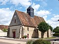
Saint-Denis church
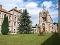
Sainte-Colombe Monastery

