Dixmont (Yonne)
| Dixmont | ||
|---|---|---|

|
|
|
| region | Bourgogne-Franche-Comté | |
| Department | Yonne | |
| Arrondissement | Sens | |
| Canton | Villeneuve-sur-Yonne | |
| Community association | Grand Sénonais | |
| Coordinates | 48 ° 5 ' N , 3 ° 25' E | |
| height | 115-246 m | |
| surface | 42.18 km 2 | |
| Residents | 914 (January 1, 2017) | |
| Population density | 22 inhabitants / km 2 | |
| Post Code | 89500 | |
| INSEE code | 89142 | |
| Website | http://www.dixmont-yonne.fr/ | |
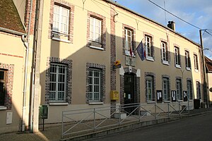
 Town Hall (Mairie) of Dixmont |
||
Dixmont is a French municipality with 914 inhabitants (at January 1, 2017) in the department of Yonne in the region Bourgogne Franche-Comté (before 2016 Bourgogne ). Dixmont belongs to the Arrondissement of Sens and the canton of Villeneuve-sur-Yonne .
geography
Dixmont is located about 20 kilometers south-southeast of the city center of Sens on the Saint-Ange river . Dixmont is surrounded by the neighboring communities of Les Bordes in the north, Vaumort in the north and northeast, Cerisiers in the northeast, Villechétive in the east, Bussy-en-Othe in the east and southeast, Joigny in the south, Villevallier and Armeau in the southwest and Villeneuve-sur-Yonne in the West.
Population development
| year | 1881 | 1962 | 1968 | 1975 | 1982 | 1990 | 1999 | 2006 | 2013 |
| Residents | 1,642 | 680 | 618 | 539 | 584 | 662 | 807 | 896 | 873 |
| Source: Cassini and INSEE | |||||||||
Attractions
- Saint-Gervais-et-Saint-Protais church from the 12th century, Monument historique
- Ruins of the priory L'Enfourchure, founded in 1209, monument historique since 1926
Web links
Commons : Dixmont - collection of images, videos and audio files


