
Courgenay (Yonne)
| Courgenay | ||
|---|---|---|
|
||
| region | Bourgogne-Franche-Comté | |
| Department | Yonne | |
| Arrondissement | Sens | |
| Canton | Brienon-sur-Armançon | |
| Community association | Vanne et du Pays d'Othe | |
| Coordinates | 48 ° 17 ' N , 3 ° 33' E | |
| height | 110-240 m | |
| surface | 29.87 km 2 | |
| Residents | 565 (January 1, 2017) | |
| Population density | 19 inhabitants / km 2 | |
| Post Code | 89190 | |
| INSEE code | 89122 | |

Courgenay is a French commune with 565 inhabitants (as of January 1, 2017) in the Yonne department in the Bourgogne-Franche-Comté region (before 2016 Bourgogne ). It is part of the canton of Brienon-sur-Armançon (until 2015: Canton of Villeneuve-l'Archevêque ).
geography
Courgenay is about 22 kilometers east-northeast of Sens and about 55 kilometers west of Troyes . Courgenay is surrounded by the neighboring communities of Saint-Maurice-aux-Riches-Hommes in the north and north-west, Bercenay-le-Hayer in the north and north-east, Pouy-sur-Vannes in the east and north-east, Bagneaux in the south-east, Villeneuve-l'Archevêque and Molinons in the south and Lailly in the south and west.
Population development
| year | 1962 | 1968 | 1975 | 1982 | 1990 | 1999 | 2006 | 2013 |
|---|---|---|---|---|---|---|---|---|
| Residents | 428 | 472 | 455 | 408 | 463 | 446 | 526 | 548 |
| Source: Cassini and INSEE | ||||||||
Attractions
- Vauluisant Monastery , Cistercian monastery, founded in 1129 (construction from 1127), dissolved in 1791, monument historique since 1930/1951
- Saint-Crépin-et-Saint-Crépinien church
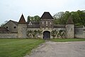
Valuisant Monastery

Saint-Crépin-et-Saint-Crépinien church


Web links
Commons : Courgenay - collection of images, videos and audio files