
Arces-Dilo
| Arces-Dilo | ||
|---|---|---|
|
||
| region | Bourgogne-Franche-Comté | |
| Department | Yonne | |
| Arrondissement | Sens | |
| Canton | Brienon-sur-Armançon | |
| Community association | Vanne et du Pays d'Othe | |
| Coordinates | 48 ° 6 ′ N , 3 ° 36 ′ E | |
| height | 198-288 m | |
| surface | 27.02 km 2 | |
| Residents | 605 (January 1, 2017) | |
| Population density | 22 inhabitants / km 2 | |
| Post Code | 89320 | |
| INSEE code | 89014 | |

Arces-Dilo is a French municipality with 605 inhabitants (as of January 1 2017) in the department of Yonne in the region Bourgogne Franche-Comté . Arces-Dilo is part of the Arrondissement of Sens and the Canton of Brienon-sur-Armançon (until 2015: Canton Cerisiers ).
geography
Arces-Dilo is about 16 kilometers east-southeast of the city center of Sens . Arces-Dilo is surrounded by the neighboring communities of Vaudeurs in the north and northwest, Coulours in the north, Fournaudin in the northeast, Venizy in the east and southeast, Champlost in the southeast, Bellechaume in the south, Bussy-en-Othe in the west and southwest and Villechétive in the west and Northwest.
The former route nationale 5 (today's D905) runs through the municipality .
history
In 1977 the municipalities of Arces and Dilo were merged.
Population development
| year | 1962 | 1968 | 1975 | 1982 | 1990 | 1999 | 2006 | 2013 | |
| Residents | 553 | 489 | 493 | 485 | 513 | 593 | 592 | 641 | |
| Source: Cassini and INSEE | |||||||||
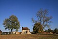
Attractions
- Saint-Michel in Arces church from the 18th century
- Chapel of Saint-Cartault in Dilo from the late 17th century
- Remains of the Premonstratensian Abbey of Notre-Dame in Dilo, founded in 1132, dissolved in 1791

Pigeon tower of the former Dilo Abbey
Saint-Cartault Chapel

