
Montacher-Villegardin
| Montacher-Villegardin | ||
|---|---|---|
|
||
| region | Bourgogne-Franche-Comté | |
| Department | Yonne | |
| Arrondissement | Sens | |
| Canton | Gâtinais en Bourgogne | |
| Community association | Gâtinais en Bourgogne | |
| Coordinates | 48 ° 10 ′ N , 3 ° 2 ′ E | |
| height | 128-164 m | |
| surface | 29.2 km 2 | |
| Residents | 766 (January 1, 2017) | |
| Population density | 26 inhabitants / km 2 | |
| Post Code | 89150 | |
| INSEE code | 89264 | |
 Town hall (Mairie) of Montacher-Villegardin |
||

Montacher-Villegardin is a French commune with 766 inhabitants (as of January 1, 2017) in the Yonne department in the Burgundy region . The municipality belongs to the Arrondissement Sens and the canton Gâtinais en Bourgogne (until 2015: canton Chéroy ). The inhabitants are called Achéromontains .
geography
Montacher-Villegardin is located about 19 kilometers west-southwest of Sens on the small Lunain river in the fertile landscape of the Gâtinais . Montacher-Villegardin is surrounded by the neighboring communities of Chéroy in the north and north-west, Dollot in the north and north-east, Saint-Valérien in the east, La Belliole in the east and south-east, Domats in the south, Bazoches-sur-le-Betz in the south-west and Jouy in the west .
history
In 1965 the municipalities of Montacher and Villegardin were merged.
Population development
| 1962 | 1968 | 1975 | 1982 | 1990 | 1999 | 2006 | 2012 |
|---|---|---|---|---|---|---|---|
| 446 | 529 | 509 | 537 | 534 | 597 | 689 | 778 |
| Source: Cassini and INSEE | |||||||
Attractions
- Menhir La Pierre Pointe
- Church in Montacher
- Church in Villegardin

Menhir La Pierre Pointe
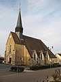
Church in Montacher

Church in Villegardin


