
Saint-Loup-d'Ordon
| Saint-Loup-d'Ordon | ||
|---|---|---|
|
||
| region | Bourgogne-Franche-Comté | |
| Department | Yonne | |
| Arrondissement | Sens | |
| Canton | Joigny | |
| Community association | Cléry, Betz et l'Ouanne | |
| Coordinates | 48 ° 1 ′ N , 3 ° 10 ′ E | |
| height | 151-194 m | |
| surface | 17.67 km 2 | |
| Residents | 256 (January 1, 2017) | |
| Population density | 14 inhabitants / km 2 | |
| Post Code | 89330 | |
| INSEE code | 89350 | |
 Town hall (Mairie) of Saint-Loup-d'Ordon |
||

Saint-Loup-d'Ordon is a French commune in the Yonne department ( Region Bourgogne Franche-Comté ) in Arrondissement Sens and in the canton of Joigny (2015: Canton Saint-Julien-du-Sault ). The community has 256 inhabitants (as of January 1, 2017).
geography
Saint-Loup-d'Ordon is about 47 kilometers northwest of Auxerre . Saint-Loup-d'Ordon is surrounded by the neighboring communities of Piffonds in the north, Saint-Martin-d'Ordon in the north and east, Cudot in the south and south-east, Charny Orée de Puisaye in the south, Douchy-Montcorbon in the south-west and Courtenay in the west .
The A6 autoroute runs through the municipality .
Population development
| year | 1962 | 1968 | 1975 | 1982 | 1990 | 1999 | 2006 | 2013 |
|---|---|---|---|---|---|---|---|---|
| Residents | 273 | 235 | 195 | 227 | 199 | 212 | 227 | 258 |
| Source: Cassini and INSEE | ||||||||
Attractions
- Saint-Loup church from the 12th century, renovations up to the 15th century
- Ordon Castle

Saint-Loup church
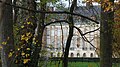
Ordon Castle

_France.jpg)
Web links
Commons : Saint-Loup-d'Ordon - Collection of images, videos and audio files