
Thésée
| Thésée | ||
|---|---|---|
|
||
| region | Center-Val de Loire | |
| Department | Loir-et-Cher | |
| Arrondissement | Romorantin-Lanthenay | |
| Canton | Saint-Aignan | |
| Community association | Val de Cher-Controis | |
| Coordinates | 47 ° 20 ′ N , 1 ° 18 ′ E | |
| height | 61-122 m | |
| surface | 17.61 km 2 | |
| Residents | 1,132 (January 1, 2017) | |
| Population density | 64 inhabitants / km 2 | |
| Post Code | 41140 | |
| INSEE code | 41258 | |

Thésée is a French commune with 1,132 inhabitants (as of January 1 2017) in the department of Loir-et-Cher in the region Center-Val de Loire . It belongs to the Arrondissement Romorantin-Lanthenay and the Canton of Saint-Aignan . The inhabitants are called Théséens .
geography
Thésée is located about 29 kilometers south of Blois on the Cher River , which borders the municipality to the west and into which the Rennes River flows here. Thésée is surrounded by the neighboring communities Monthou-sur-Cher in the north and northwest, Choussy in the northeast, Saint-Romain-sur-Cher in the east, Mareuil-sur-Cher in the south and Pouillé in the west.
The A85 car route runs through the south of the municipality .
history
As Tasciaca it was an early settlement on the Roman road from Tours to Bourges . The remains of the buildings in the Maselles district can be dated to the second century AD.
Population development
| year | 1962 | 1968 | 1975 | 1982 | 1990 | 1999 | 2006 | 2013 |
| Residents | 1,035 | 1,117 | 1,075 | 1,111 | 1,074 | 1,123 | 1,238 | 1,177 |
| Source: Cassini and INSEE | ||||||||
Attractions
- Saint-Georges church
- Gallo-Roman remains, Monument historique since 1841, with archaeological museum
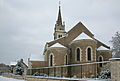
Saint-Georges church

roman ruins
._L%27%C3%A9glise_Saint-Georges.jpg)
