Romorantin-Lanthenay
| Romorantin-Lanthenay | ||
|---|---|---|

|
|
|
| region | Center-Val de Loire | |
| Department | Loir-et-Cher | |
| Arrondissement | Romorantin-Lanthenay | |
| Canton | Romorantin-Lanthenay (main town) | |
| Community association | Romorantinais et du Monestois | |
| Coordinates | 47 ° 21 ′ N , 1 ° 45 ′ E | |
| height | 84-121 m | |
| surface | 45.31 km 2 | |
| Residents | 17,754 (January 1, 2017) | |
| Population density | 392 inhabitants / km 2 | |
| Post Code | 41200 | |
| INSEE code | 41194 | |
| Website | http://www.romorantin.fr/ | |
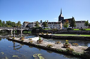
 View over the Sauldre to the city |
||
Romorantin is a French municipality with 17,754 inhabitants (at January 1, 2017) in the Loir-et-Cher in the region Center-Val de Loire . It is the administrative seat of the Arrondissement Romorantin-Lanthenay and the capital of the canton Romorantin-Lanthenay , before the cantonal restructuring in 2015 the place was divided into the cantons Romorantin-Lanthenay-Nord and Romorantin-Lanthenay-Sud .
geography
Romorantin-Lanthenay is located in the wooded landscape of Sologne on the Sauldre in central France, about 65 kilometers south of Orléans and about 40 kilometers southwest of the prefecture of Blois .
Neighboring municipalities are Millançay , Veilleins , Pruniers-en-Sologne , Villeherviers and Villefranche-sur-Cher .
history
The city was created on May 29, 1961 by merging the municipalities of Romorantin (1882: 7,826 inhabitants) and Lanthenay (1882: 2,094 inhabitants). With the merger of Romorantin and Lanthenay, the community became the second largest city in the department.
Romorantin was mentioned for the first time in 1196 in a charter from the Count of Blois . It was the old capital of the Sologne countryside. Here the Chancellor l'Hôpital issued the famous edict of Romorantin in May 1560 against the introduction of the Inquisition in France. The place developed an important trade in wool processing and cloth weaving. The last textile factory closed in 1969.
The airfield Romorantin-Pruniers was in World War an important base of the American Expeditionary Force.
| Population development | ||||||||
|---|---|---|---|---|---|---|---|---|
| year | 1962 | 1968 | 1975 | 1982 | 1990 | 1999 | 2012 | 2017 |
| Residents | 11,777 | 14.096 | 16,719 | 17,692 | 17,865 | 18,350 | 16,746 | 17,754 |
Attractions
- Musee de Sologne
- Musée Matra (sports car)
- The former church of Monthault from the 12th to 15th centuries stands today in the urban area of Romorantin-Lanthenay. It is now privately owned and has been on the list of Monuments historiques since 1936 .
- Parish Church of Notre-Dame and Saint-Etienne de Romorantin (11th to 13th century), partly as historique monument classified
- Parish Church of Saint-Pierre, Saint-Paul, Saint-Laurent et Saint-Aignan de Lanthenay (12th century)
- Remains of the former Notre-Dame-du-Lieu abbey (13th to 14th centuries)
- Hôtel Saint-Paul , called Maison de François Ier , 16th century ( Monument historique )
- The Carroir doré , a wooden- walled house that houses the archaeological museum
- The Chancellerie (Chancellery), a house with wooden walls, 16th century, which houses the royal seals of Francis I ( Monument historique )
- The Dolmen Pierre Couverte von Bué is located in a wooded area in the hamlet of Bué, southeast of Bagneux near Romorantin-Lanthenay
Town twinning
Sister cities of Romorantin-Lanthenay are:
- Long Eaton , UK, since 1961
- Langen (Hessen) , Germany, since 1968
- Aranda de Duero , Spain, since 2008
- Mudanya , Turkey, since 2012
In 1971 the three-way partnership between Romorantin, Langen and Long-Eaton was sealed.
Personalities
- The future Queen Claude de France (1499-1524) was born on October 13, 1499 in Romorantin.
- Alfred Cornu (1841–1902), physicist, died here in 1902.
- Rémy Dumoncel (1888–1945), publisher, mayor of Avon and resistance fighter, was born here in 1888.

