
La Ferté-Beauharnais
| La Ferté-Beauharnais | ||
|---|---|---|

|
|
|
| region | Center-Val de Loire | |
| Department | Loir-et-Cher | |
| Arrondissement | Romorantin-Lanthenay | |
| Canton | Chambord | |
| Community association | Sologne des Étangs | |
| Coordinates | 47 ° 33 ' N , 1 ° 51' E | |
| height | 95-109 m | |
| surface | 2.42 km 2 | |
| Residents | 525 (January 1, 2017) | |
| Population density | 217 inhabitants / km 2 | |
| Post Code | 41210 | |
| INSEE code | 41083 | |

La Ferte-Beauharnais is a French village with 525 inhabitants (as of January 1 2017) in Loir-et-Cher in the region Center-Val de Loire ; it belongs to the arrondissement Romorantin-Lanthenay and the canton Chambord (until 2015: canton Neung-sur-Beuvron ).
geography
La Ferté-Beauharnais is located about 31 kilometers east-southeast of Blois and about 42 kilometers south-southwest of Orléans in the Sologne . La Ferté-Beauharnais is surrounded by the neighboring communities of Neung-sur-Beuvron in the north, west and south and Saint-Viâtre in the north, east and south.
Population development
| year | 1962 | 1968 | 1975 | 1982 | 1990 | 1999 | 2006 | 2013 |
| Residents | 468 | 454 | 392 | 400 | 442 | 463 | 516 | 522 |
| Source: Cassini and INSEE | ||||||||
Attractions
- Saint-Barthélemy Church, originally built in 1149, rebuilt in 1524
- Beauharnais Castle from the 18th century
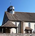
Saint Barthélemy Church
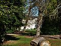
Beauharnais Castle
.jpg)

Personalities
- Daniel Brottier (1876–1936), missionary, beatified in 1984
Web links
Commons : La Ferté-Beauharnais - Collection of images, videos and audio files