
Villeneuve-sur-Cher
| Villeneuve-sur-Cher | ||
|---|---|---|
|
||
| region | Center-Val de Loire | |
| Department | Cher | |
| Arrondissement | Bourges | |
| Canton | Chârost | |
| Community association | Fercher Pays Florentais | |
| Coordinates | 47 ° 2 ' N , 2 ° 13' E | |
| height | 113-159 m | |
| surface | 26.13 km 2 | |
| Residents | 444 (January 1, 2017) | |
| Population density | 17 inhabitants / km 2 | |
| Post Code | 18400 | |
| INSEE code | 18285 | |

Villeneuve-sur-Cher is a commune with 444 inhabitants (as of January 1 2017) in the department of Cher in the region Center-Val de Loire . It belongs to the Arrondissement of Bourges and the Canton of Chârost . The inhabitants are called Villeneuvois .
geography
Villeneuve-sur-Cher is located about 15 kilometers west-southwest of Bourges on the Cher . Villeneuve-sur-Cher is surrounded by the neighboring communities of Sainte-Thorette in the north and north-west, Morthomiers in the east, Saint-Florent-sur-Cher in the south, Civray in the west and south-west and Plou in the west.
The community is located on Via Lemovicensis , one of the four historic " Way of the Pilgrims in France ".
Population development
| year | 1962 | 1968 | 1975 | 1982 | 1990 | 1999 | 2006 | 2013 |
| Residents | 372 | 358 | 321 | 371 | 425 | 469 | 422 | 461 |
| Source: Cassini and INSEE | ||||||||
Attractions
- Dolmen La Pierre de la Roche
- Saint-Pierre church from the 12th century
- old castle
- 18th century tower
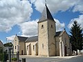
Saint-Pierre church

old castle

tower


literature
- Le Patrimoine des Communes du Cher. Flohic Editions, Volume 1, Paris 2001, ISBN 2-84234-088-4 , pp. 307-309.
Web links
Commons : Villeneuve-sur-Cher - Collection of images, videos and audio files