Way of the pilgrims of St. James in France
| Way of the pilgrims of St. James in France | |
|---|---|
|
UNESCO world heritage |
|

|
|
|
Saint-Jean-Pied-de-Port ( ) marks the end of the Via Podiensis |
|
| National territory: |
|
| Type: | Culture |
| Criteria : | (ii) (vi) (vi) |
| Reference No .: | 868 |
| UNESCO region : | Europe and North America |
| History of enrollment | |
| Enrollment: | 1998 (session 22) |
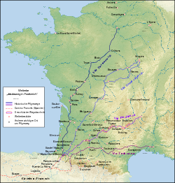
Under the name “ Paths of the Pilgrims in France ”, UNESCO has summarized the four Camino de Santiago that run through France , Via Lemovicensis , Via Podiensis , Via Tolosana and Via Turonensis .
enrollment
The inscription in the list of the UNESCO World Heritage took place during the 22nd meeting of the World Heritage Committee from November 30 to December 5, 1998 in the Japanese city of Kyoto .
The following criteria were met at the time of registration on the World Heritage List:
- ii: The goods show, for a period of time or in a cultural area of the earth, a significant intersection of human values in relation to the development of architecture or technology, large-scale sculpture, urban planning or landscape design.
- iv: The goods represent an excellent example of a type of building, architectural or technological ensemble or landscape that symbolizes one or more significant periods of human history.
- vi: The goods are linked in a direct or recognizable manner to events or traditional ways of life, to ideas or creeds, or to artistic or literary works of exceptional universal importance.
description
The Way of St. James ( French Pèlerinage de Saint-Jacques-de-Compostelle , Spanish Camino de Santiago ) is a number of pilgrimage routes across Europe, all of which aim at the alleged tomb of the Apostle James in Santiago de Compostela in Galicia, Spain . First and foremost, it is understood as the Camino Francés , that high medieval main traffic axis in northern Spain, which leads from the Pyrenees to Jacob's tomb and connects the royal cities of Jaca , Pamplona , Estella , Burgos and León .
Origin of name
The Camino de Santiago was first mentioned in 1047. In a document from the Arconada Hospital, Province of Palencia , the main thoroughfare in northern Spain is referred to as "the path that has been used by pilgrims of St. James and Peter and Paul since ancient times".
In contrast, an international commission of experts set up by the Council of Europe in 1985 and settled in the government of the autonomous region of Galicia agreed on a nomenclature according to which only the northern Spanish main traffic axis should be called Camino de Santiago (St. James' Way). All other routes are known as the “Way of the Pilgrims”.
In France, the restoration of the network of paths is based on a complex system of classifications that the Center d'études compostellanes in Paris introduced in the 1980s: Only the four main routes, Via Turonensis , Via Lemovicensis , Via Podiensis and, are considered to be the “Paths of the St. James ” Via Tolosana , which was mentioned in the pilgrim guide (5th book of Liber Sancti Jacobi ) as early as the 12th century . The Itinéraires form a second category ; these are further routes for which historical pilgrim guides or pilgrimage reports are available. The third category is the cheminements ; these are routes that are proven by documents such as customs books or passers-by lists from hospitals and other evidence as the routes of the pilgrims to St. James.
In collaboration with the Fédération française de la randonnée pédestre, the main trails have been designated as GR long-distance hiking trails .
Main ways
Via Lemovicensis
The Via Lemovicensis (French: Voie limousine or Voie de Vézelay ) runs from Vézelay with its basilica Ste-Marie-Madeleine ( ) in different variants over the eponymous Limoges to Ostabat ( ) at the foot of the Pyrenees in the Pyrénées-Atlantiques department in the region Nouvelle-Aquitaine .
![]()
![]()
Here the Via Lemovicensis meets the Via Turonensis and the Via Podiensis .
Via Podiensis
The Via Podiensis ( Latin via = path, podium = Le Puy (dt. 'Hilltop')) leads from the Notre-Dame Cathedral ( ) in Le Puy-en-Velay in Auvergne over the Massif Central , through the Dourdou de gorge Conques , along the Lot to Cahors and through Gascony to Ostabat.
![]()
Via Tolosana
The Via Tolosana (French: voie toulousaine) has its meeting point and start in Arles ( ) on the Rhone , here pilgrims from Italy and Provence as well as from the northern Rhone Valley gather . It runs over Vauvert , Olargues , Sorèze , Toulouse , Marciac , Lurbe-Saint-Christau and over the Col du Somport to Puente la Reina .
![]()
Via Turonensis
The Via Turonensis is the northernmost route for pilgrims through France. It leads from the Saint-Jacques tower ( ) in the Parisian Quartier du Châtelet via Orléans , Saint-Dyé-sur-Loire , the eponymous city of Tours , Poitiers , Bordeaux and Saint-Paul-lès-Dax to Ostabat.
![]()
See also
Web links
Individual evidence
- ↑ 22nd meeting of the World Heritage Committee ( English ); accessed on May 27, 2020.


