
Reunion National Park
| Reunion National Park | |
|---|---|
 |
|
 |
|
| Location: | Reunion Island , France |
| Next city: | Saint-Denis (Réunion) |
| Surface: | 1,054.47 km² |
| Founding: | March 5, 2007 |
| Address: | www.reunion-parcnational.fr |
 |
|
 |
|
 |
|
The Réunion National Park on the island of Réunion in the Indian Ocean has been France's ninth national park since 2007 .
The park, whose core area takes up a good 40% of the island, was founded to protect endemic animal and plant species on the island of Réunion . In real estate, there are three times more endemic species on Reunion than on Hawaii and five times more endemic species than on the Galapagos Islands .
In 2010, the Réunion National Park was included in the UNESCO World Heritage list under the title: Pitons, cirques et remparts de l'île de La Réunion (Eng. "Summit, basin and steep slopes of the island of Réunion") .
The national park includes both the extinct volcano Piton des Neiges and the three basins Cirque de Cilaos , Cirque de Mafate and Cirque de Salazie , as well as the active volcano Piton de la Fournaise on the south side of the island.
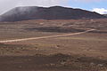
The Plaine des Sables (sand plain) at the Piton de la Fournaise
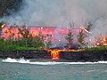
Eruption of the Piton de la Fournaise volcano
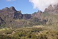
The Cirque de Mafate basin


Web links
- Entry in the Unesco World Heritage Site on the Réunion National Park website (French)
- Reunion National Park website (French)
- Unesco - Patrimoine mondial: Pitons, cirques et remparts de l'ile de la Réunion (French)
Individual evidence
- ↑ Conseil d'État : Decree No. 2007-296 of March 5, 2007 establishing the Réunion National Park . Retrieved April 6, 2008.
- ↑ UNESCO World Heritage Center: Pitons, cirques and remparts of Reunion Island. Retrieved August 20, 2017 .

Historic city centers:
Episcopal city of Albi (2010) |
Roman and Romanesque Monuments of Arles (1981) |
Papal Palace , Cathedral and Avignon Bridge (1995) |
Bordeaux , Port de la Lune (2007) |
Carcassonne (1997) |
Le Havre (2005) |
Lyon (1998) |
Stanislas, de la Carrière and d'Alliance squares in Nancy (1983) |
Seine River from Paris (1991) |
Provins , city of medieval fairs (2001) |
Strasbourg: from Grande-Île to New Town (1988, 2017) |
Vézelay abbey church and hill (1979)
Structures: Fontenay Abbey (1981) | Saint-Savin Abbey (1983) | Belfries in Belgium and France (2005) | Canal du Midi (1996) | The architectural work of Le Corbusier (2016) | Vauban's fortifications (2008) | Great Saltworks of Salins-les-Bains and Royal Saltworks of Arc-et-Senans (1982) | Amiens Cathedral (1981) | Bourges Cathedral (1992) | Chartres Cathedral (1979) | Mont-Saint-Michel and its bay (1979) | Pont du Gard (1985) | Notre Dame Cathedral, former Saint-Remi Abbey and Palais du Tau in Reims (1991) | Fontainebleau Castle and its Park (1981) | Palace and Park of Versailles (1979) | Orange Theater and Arc de Triomphe (1981)
Archaeological sites:
Chauvet grotto near Vallon-Pont-d'Arc (2014) |
Prehistoric pile dwellings around the Alps (2011) |
Vézère valley: sites and cave paintings (1979)
Cultural and natural landscapes: Nord-Pas de Calais mining area (2012, K) | District Saint-Emilion (1999 K) | Causses and Cevennes (2011, K) | Climats - vineyards in Burgundy (2015, K) | French Southern and Antarctic Lands (2019, N) | Way of the pilgrims in France (1998, K) | Gulf of Porto: Piana Calanche, Gulf of Girolata and Scandola Nature Reserve (1983, N) | Mont Perdu (1997, K / N) | New Caledonia lagoons (2008, N) | Loire Valley - Between Sully-sur-Loire and Chalonnes-sur-Loire (2000, K) | Taputapuātea (2017, K) | Volcanic landscape on La Réunion (2010, N) | Vineyards, wine houses and wine cellars of Champagne (2015, K)