
Écrins National Park
| Écrins National Park | |||
|---|---|---|---|
 |
|||
|
|||
| Location: | Hautes-Alpes , Isere , France | ||
| Surface: | 270,200 ha | ||
| Founding: | March 27, 1973 | ||
| Address: |
Website of the Domaine de Charance National Park F-05000 Gap |
||
 |
|||

The Écrins National Park ( French : Parc National des Écrins ) covers part of the Dauphiné Alps ( Provencal Alps- Hautes-Alpes ) in south-east France . Bigger cities in the area are Gap (Hautes-Alpes) , Grenoble and Briançon .
The national park was founded in 1973 and has an area of approximately 1,786 square kilometers. A core zone of 918 square kilometers is particularly protected. The center of the national park is the Pelvoux massif, with the Barre des Écrins, the southernmost four-thousand-meter peak in the Alps .
Nature and environmental protection
In 1990 the National Park was awarded the European Diploma for Protected Areas by the Council of Europe . The Écrins National Park has been on France's list of UNESCO World Heritage Sites since 2002 .
photos

Lac de la Douche
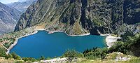
Lac de Lauvitel
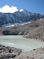
D'Arsine glacier

Lake Combeynot
.jpg)

.JPG)

See also
Web links
- Official website of the national park
- Tour descriptions for the Écrins National Park
- World Database on Protected Areas - Écrins National Park (English)
Individual evidence
- ↑ Parc national des Écrins. UNESCO World Heritage Center, February 1, 2002, accessed January 15, 2018 (French).