Isère department
| Isère | |
|---|---|
| region | Auvergne-Rhône-Alpes |
| prefecture | Grenoble |
| Sub-prefecture (s) |
La Tour-du-Pin Vienne |
| Residents | 1,258,722 (Jan. 1, 2017) |
| Population density | 169 inhabitants per km² |
| surface | 7,429.83 km² |
| Arrondissements | 3 |
| Community associations | 20th |
| Cantons | 29 |
| Communities | 512 |
|
President of the Department Council |
André Vallini |
| ISO-3166-2 code | FR-38 |
 Location of Isère in the region Auvergne Rhône-Alpes |
|
The Isère department [ izɛːʀ ] is the French department with the atomic number 38. It is in the southeast of the country in the region Auvergne Rhône-Alpes and is named after the river Isère named.
geography
The Isère department borders the Rhône , Ain , Savoie , Hautes-Alpes , Drôme , Ardèche and Loire departments .
history
The department was formed on March 4, 1790 from parts of the Dauphiné province .
From 1960 to 2015 it was part of the Rhône-Alpes region , which in 2016 became part of the Auvergne-Rhône-Alpes region.
coat of arms
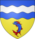
Description : Divided into blue and gold by a wavy cut; above a silver wave bar and below a red-faced blue dolphin .
Cities
- Grenoble , 160,215 inhabitants
- Saint-Martin-d'Hères , 39,015 inhabitants
- Échirolles , 35,816 inhabitants
- Vienne , 29,325 inhabitants
- Bourgoin-Jallieu , 27,163 inhabitants
- Fontaine , 22,066 inhabitants
Administrative division
The Isère department consists of 3 arrondissements , 29 cantons and 521 communes.
| Arrondissement | Cantons | Communities | Residents January 1, 2017 |
Area km² |
Density of population / km² |
Code INSEE |
|---|---|---|---|---|---|---|
| Grenoble | 19th | 263 | 739.837 | 4,396.14 | 168 | 381 |
| La Tour-du-Pin | 8th | 136 | 305,542 | 1,544.03 | 198 | 382 |
| Vienne | 6th | 113 | 213,343 | 1,489.66 | 143 | 383 |
| Isère department | 29 | 512 | 1,258,722 | 7,429.83 | 169 | 38 |
See also
- List of communes in the Isère department
- List of cantons in the Isère department
- List of associations of municipalities in the Isère department
Web links
- General Council of the Isère Department (French)
- Prefecture of the Isère Department (French)
- Aéroport de Grenoble-Isère (French, English)
Individual evidence
- ↑ Archive link ( Memento of the original from March 9, 2014 in the Internet Archive ) Info: The archive link was inserted automatically and has not yet been checked. Please check the original and archive link according to the instructions and then remove this notice. Retrieved September 5, 2012
Coordinates: 45 ° 11 ' N , 5 ° 43' E


