Lot-et-Garonne department
| Lot-et-Garonne | |
|---|---|
| region | Nouvelle-Aquitaine |
| prefecture | Agen |
| Sub-prefecture (s) |
Marmande Nérac Villeneuve-sur-Lot |
| Residents | 332,842 (Jan. 1, 2017) |
| Population density | 62 inhabitants per km² |
| surface | 5,360.91 km² |
| Arrondissements | 4th |
| Community associations | 13 |
| Cantons | 21st |
| Communities | 319 |
|
President of the Department Council |
Pierre Camani |
| ISO-3166-2 code | FR-47 |
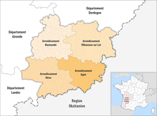
 Location of the department of Lot-et-Garonne in the region Nouvelle-Aquitaine |
|
The Lot-et-Garonne [ lɔtegaʀɔn ] is the French department with the atomic number 47. It is in the southwest of the country in the region Nouvelle-Aquitaine and on the rivers Lot and Garonne named.
geography
The department is located in the east of the Nouvelle-Aquitaine region. It borders the Dordogne department to the north, the Lot , Tarn-et-Garonne and Gers departments of the Occitania region to the east, southeast and south , and the Landes and Gironde departments to the southwest and west .
The most important rivers are the eponymous Garonne , which crosses the department from south-east to north-west, passing the capital Agen in the south-east , and the eponymous Lot , which runs through the department in an east-west direction until it becomes a right tributary in Aiguillon the Garonne flows into. The forest area of Forêt des Landes , which extends to the Atlantic coast , covers the west of the department .
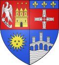
coat of arms
Description : The coat of arms is quartered :
- Field 1 is red and has the right one ansitz end silver eagle on a pole made silver piece of wood with the inscription in black letters "AGEN" and left a golden brick castle with black door and windows, two stepped side towers and a higher central tower with battlements and pointed roof. On each of the towers a golden flag waving to the left.
- Field 2 is red and under the blue head of the shield with the three golden lilies , four silver crenellated towers form a common cross , in the middle of which is a silver cross with crutches .
- Field 3 is blue with a golden sun with a face.
- Field 4 in blue is a silver, black-grooved stone bridge with five arches under which a silver corrugated shield is located. On the pointed bridge there are three stone towers of the same kind, the middle one is the larger one, and the golden lily hovers over the side towers.
history
The department was formed during the French Revolution on March 4, 1790 from parts of the then provinces of Guyenne and Gascogne (mainly the Agenais and the eastern part of the Bazadais ). It was divided into nine districts (French: district), the forerunners of the arrondissements . The districts were Agen, Casteljaloux, Lauzun, Marmande, Monflanquin, Nérac, Tonneins, Valence and Villeneuve. The department and the districts were divided into cantons and had around 260,000 (?) Inhabitants. The capital was already Agen.
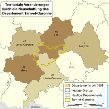
The arrondissements of Agen , Marmande , Nérac and Villeneuve-sur-Lot were established on February 17, 1800. On November 4, 1808, parts of the arrondissements of Agen and Villeneuve-sur-Lot were spun off into the newly established Tarn-et-Garonne (now Occitania region ). On September 10, 1926, the Arrondissement of Nérac was dissolved, but re-established on June 1, 1942 in the same size.
From 1960 to 2015 it belonged to the Aquitaine region , which in 2016 became part of the Nouvelle Aquitaine region.
Cities
The most populous communes in the Lot-et-Garonne department are:
| city | Population (2017) |
Arrondissement |
|---|---|---|
| Agen | 33,576 | Agen |
| Villeneuve-sur-Lot | 22,064 | Villeneuve-sur-Lot |
| Marmande | 17,691 | Marmande |
| Le passage | 9,561 | Agen |
| Tonneins | 9,069 | Marmande |
| Nérac | 6,827 | Nérac |
| Sainte-Livrade-sur-Lot | 6,459 | Villeneuve-sur-Lot |
| Bon-Encontre | 6,199 | Agen |
| Boé | 5,593 | Agen |
| Fumel | 4,834 | Villeneuve-sur-Lot |
Administrative division
The Lot-et-Garonne department is divided into 4 arrondissements , 21 cantons and 319 communes :
| Arrondissement | Cantons | Communities | Residents January 1, 2017 |
Area km² |
Density of population / km² |
Code INSEE |
|---|---|---|---|---|---|---|
| Agen | 8th | 71 | 120,796 | 1,013.25 | 119 | 471 |
| Marmande | 6th | 98 | 83,722 | 1,387.66 | 60 | 472 |
| Nérac | 3 | 58 | 38,900 | 1,400.31 | 28 | 474 |
| Villeneuve-sur-Lot | 8th | 92 | 89,424 | 1,559.69 | 57 | 473 |
| Lot-et-Garonne department | 21st | 319 | 332,842 | 5,360.91 | 62 | 47 |
See also:
- List of communes in the Lot-et-Garonne department
- List of cantons in the Lot-et-Garonne department
- List of associations of municipalities in the Lot-et-Garonne department
Web links
- Lot-et-Garonne department (French)
- Prefecture of the Lot-et-Garonne department (French)
Individual evidence
- ↑ lotetgaronne.fr accessed on May 6, 2015.
Coordinates: 44 ° 21 ' N , 0 ° 29' E


