Meurthe-et-Moselle department
| Meurthe-et-Moselle | |
|---|---|
| region | Grand Est |
| prefecture | Nancy |
| Sub-prefecture (s) |
Briey Lunéville Toul |
| Residents | 733,481 (Jan. 1, 2017) |
| Population density | 140 inhabitants per km² |
| surface | 5,245.90 km² |
| Arrondissements | 4th |
| Community associations | 20th |
| Cantons | 23 |
| Communities | 591 |
|
President of the Department Council |
Mathieu Klein |
| ISO-3166-2 code | FR-54 |
 Location of Meurthe-et-Moselle in the region Grand Est |
|
The department of Meurthe-et-Moselle [ mœʀtemɔˈzɛl ] is the French department with serial number 54. It is located in the north-east of the country in the Grand Est region and is named after the rivers Meurthe and Mosel . The capital ( prefecture , French préfecture ) is Nancy , sub-prefectures are Briey , Lunéville and Toul .
geography
The department borders in the north with the Belgian province of Luxembourg and Luxembourg , in the northeast with the department Moselle , in the extreme southeast with the department Bas-Rhin , in the south with the department Vosges and in the west with the department Meuse .
coat of arms
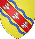
In gold, a red diagonal bar covered with three mutilated silver eagles, accompanied by two blue wavy strips diagonally to the right.
This is the coat of arms of the old Duchy of Lorraine, in the center of which the département is located, supplemented by the two blue wavy strips that symbolize the Meurthe and Moselle rivers.
history
The department was founded on September 7, 1871 with the four arrondissements Briey, Lunéville, Nancy and Toul.
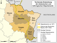
As a result of the Franco-Prussian War, Alsace and, above all, the German-speaking part of Lorraine had been annexed to the newly founded German Empire as "Reichsland" ; This mainly affected the largest part of the Moselle department and the Sarrebourg and Château-Salins of the Meurthe department . The areas of the two departments that remained with France were merged in the same year to form the new department of Meurthe-et-Moselle.
The current border between the departments of Moselle and Meurthe-et-Moselle was the state border between Germany ( German Empire ) and France ( Third French Republic ) from 1871 to 1919 . When Germany had to return the territory of the Reichsland to France as a result of the lost World War I in 1919 under the Versailles Treaty , the French state retained the border between the departments drawn in 1871.
From 1960 to 2016, the department was part of the Lorraine region , which in 2016 became part of the Grand Est region.
Cities
The most populous communes in the Meurthe-et-Moselle department are:
| city | Population (2017) |
Arrondissement |
|---|---|---|
| Nancy | 104.286 | Nancy |
| Vandœuvre-lès-Nancy | 30.002 | |
| Luneville | 18,287 | Luneville |
| Toul | 15,832 | Toul |
| Longwy | 14,378 | Briey |
| Villers-lès-Nancy | 14,415 | Nancy |
| Pont-à-Mousson | 14,228 | |
| Laxou | 14,444 | |
| Maxeville | 9,814 | |
| Saint-Max | 9,965 |
Administrative division
The department of Meurthe-et-Moselle is divided into 4 arrondissements with 23 cantons and 592 communes :
| Arrondissement | Cantons | Communities | Residents January 1, 2017 |
Area km² |
Density of population / km² |
Code INSEE |
|---|---|---|---|---|---|---|
| Briey | 6th | 128 | 166,540 | 1,142.77 | 146 | 541 |
| Luneville | 3 | 164 | 78,300 | 1,450.74 | 54 | 542 |
| Nancy | 16 | 188 | 419.380 | 1,509.34 | 278 | 543 |
| Toul | 5 | 111 | 69,261 | 1,143.05 | 61 | 544 |
| Meurthe-et-Moselle department | 23 | 591 | 733.481 | 5,245.90 | 140 | 54 |
See also:
- List of communes in the Meurthe-et-Moselle department
- List of cantons in the Meurthe-et-Moselle department
- List of associations of municipalities in the Meurthe-et-Moselle department
Changes
- From 1926 to 1943, the Arrondissement of Toul was dissolved.
- In 1997, the village of Han-devant-Pierrepont from the canton of Spincourt (Arrondissement Verdun) of the Département Meuse was incorporated into the canton Longuion (Arrondissement Briey) of the Département Meurthe-et-Moselle.
- Due to a change in the electoral law in 2014, the cantons had to be redesigned from 2015. Instead of the previous 44 cantons, the département is now divided into 23 cantons, whereby these are no longer necessarily assigned to the communes of a single arrondissement.
traffic
The LGV Est européenne high-speed line runs through the Meurthe-et-Moselle department with the 1510 m long Moselle viaduct near Vandières.
Attractions
- The Place Stanislas in Nancy (World Heritage Site)
- The Lunéville Castle
- The Saint-Etienne Cathedral in Toul
- The Saint-Nicolas Basilica in Saint-Nicolas-de-Port
Web links
- Meurthe-et-Moselle (French)
- Prefecture of the department of Meurthe-et-Moselle (French)
- Literature on the Département Meurthe-et-Moselle in the catalog of the German National Library
Individual evidence
- ↑ meurthe-et-moselle.fr ( Memento of the original from November 1, 2016 in the Internet Archive ) Info: The archive link was automatically inserted and not yet checked. Please check the original and archive link according to the instructions and then remove this notice. Retrieved April 29, 2015.
Coordinates: 48 ° 41 ′ N , 6 ° 10 ′ E


