Saint-Max
| Saint-Max | ||
|---|---|---|

|
|
|
| region | Grand Est | |
| Department | Meurthe-et-Moselle | |
| Arrondissement | Nancy | |
| Canton | Saint-Max (main town) | |
| Community association | Grand Nancy | |
| Coordinates | 48 ° 42 ' N , 6 ° 12' E | |
| height | 193-342 m | |
| surface | 1.85 km 2 | |
| Residents | 9,965 (January 1, 2017) | |
| Population density | 5,386 inhabitants / km 2 | |
| Post Code | 54130 | |
| INSEE code | 54482 | |
| Website | http://www.saint-max.fr/ | |
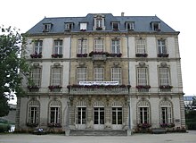
 Castle and bridge ( Pont d'Essey ) over the Meurthe |
||
Saint-Max is a French commune with 9,965 inhabitants (as of January 1, 2017) in the Meurthe-et-Moselle department in the Grand Est region (until 2015 Lorraine ). The city has an area of 185 hectares and is the capital of the canton of the same name .
geography
Saint-Max lies on the eastern bank of the Meurthe , opposite Nancy . The municipality extends to the southern slopes of the Plateau de Sainte-Geneviève and the Plateau de Malzéville at an altitude between 193 m and 342 m . The place is connected to Nancy by two bridges. Other surrounding parishes are (clockwise) Malzéville , Dommartemont , Essey-lès-Nancy and Tomblaine .
The watercourses that run through the village are channeled underground.
Surname
Saint-Max was first mentioned in 1263 under the name of Saint-Mard . Mard is an alienation of the name Médard (Medardus), the canonized bishop Medardus of Noyon , who lived in northern France in the 5th and 6th centuries.
The current name is first recorded in 1772. In between there were the names Saint-Marc (15th century), Sainct-May , Sainct-Marc , Sainct-Mach and Saint-Maix (16th century) and Saint-Mâ (17th century). During the French Revolution , the name part of Saint was suppressed and the place became Mâ-la-Montagne or Mex-la-Montagne .
history
The place was created in the vicinity of a small, probably fortified, religious building. The tower that has been preserved is the steeple of today's Saint-Médard church . From 1263, during the reign of Duke Friedrich III. from Upper Lorraine , its first written mention comes from.
In the 16th century the place was known for its wine. In 1870 it is still described as a small village, the houses of which were mainly grouped around the church. Only a few other buildings existed at the bridge to Essey.
The Treaty of Frankfurt , which in 1871 added parts of Lorraine to the German Empire , led to an influx of people into the area that had remained French. The surrounding communities benefited from the strong growth of Nancy, and the villages became suburbs. In 1866, Saint-Max still had 430 inhabitants, the number of which grew to almost 3,000 by 1911. The settlement of industrial companies in the lower quarters of Nancy, along the Paris – Strasbourg railway line and the Canal de la Marne au Rhin , also influenced population development.
Around the Saint-Livier church from 1883 and the newly created main street, Rue Carnot , a district emerged that became the new center of the town. In 1881 the horse-drawn tram from Nancy reached the municipal boundary at the bridge over the Meurthe , the Pont d'Essey . In 1903, a stretch of the electric tram was approved along Avenue Carnot towards Essey, which is believed to have been in service before 1908. On December 2, 1958, this line was discontinued as the last of the Nancy tram , in 1983 a trolleybus line was established instead .
Population development
The population also grew steadily during the world wars and in the interwar period . After the Second World War , governments encouraged the construction of residential buildings, which created new streets and neighborhoods. Almost the entire municipality is now built on. In 1968 the maximum population was reached with 12,489 inhabitants, since then the number of inhabitants has decreased again.
| year | 1793 | 1861 | 1881 | 1901 | 1921 | 1936 | 1946 | 1954 | 1962 | 1968 | 1975 | 1982 | 1990 | 1999 | 2007 | 2017 |
|---|---|---|---|---|---|---|---|---|---|---|---|---|---|---|---|---|
| Residents | 200 | 380 | 1427 | 2058 | 3427 | 4996 | 5380 | 6660 | 8521 | 12,489 | 12,463 | 11,656 | 11,075 | 10,939 | 10,050 | 9965 |
traffic
The main axis is the avenue Carnot or Départementsstraße 2074 leading from Nancy to Essey-lès-Nancy. It begins at the bridge over the Meurthe and leads in a straight line in a north-easterly direction to Essey. Trolleybuses of line 1 of the Tramway de Nancy run along their entire length , from the area where the lane guidance is located on the western edge of the town, apart from the driver, is guided in the street space. The line has three stops in the municipality.
Départementsstraße 32A runs parallel to the river on the western outskirts with Rue Alexandre 1er , and Départementsstraße 33A to the north of Avenue Carnot. The nearest train station is Nancy train station, about three kilometers away , which can be reached by tram without changing trains.
Town twinning
- Walldorf , Germany, since 1985
Personalities
- Manuel da Costa (* 1986), Portuguese-Moroccan football player
Web links
- Official website (French)
Individual evidence
- ↑ a b c Website of the city of Saint-Max (French) ( Memento of the original from January 7, 2017 in the Internet Archive ) Info: The archive link was inserted automatically and has not yet been checked. Please check the original and archive link according to the instructions and then remove this notice. , accessed November 24, 2013.


