
Bey-sur-Seille
| Bey-sur-Seille | ||
|---|---|---|

|
|
|
| region | Grand Est | |
| Department | Meurthe-et-Moselle | |
| Arrondissement | Nancy | |
| Canton | Entre Seille et Meurthe | |
| Community association | Seille and Grand Couronné | |
| Coordinates | 48 ° 48 ' N , 6 ° 21' E | |
| height | 195-243 m | |
| surface | 5.53 km 2 | |
| Residents | 169 (January 1, 2017) | |
| Population density | 31 inhabitants / km 2 | |
| Post Code | 54610 | |
| INSEE code | 54070 | |

Bey-sur-Seille is a French commune with 169 inhabitants (as of January 1, 2017) in the Meurthe-et-Moselle department in the Grand Est region (until 2015 Lorraine ). The municipality belongs to the arrondissement of Nancy and the canton Entre Seille et Meurthe (until 2015: canton Nomeny ).
location
Bey-sur-Seille is located about 15 kilometers east-northeast of Nancy on the Seille , which borders the municipality in the east. Bey-sur-Seille is surrounded by the neighboring communities of Lanfroicourt in the north and north-west, Aboncourt-sur-Seille in the north-east, Bioncourt in the east, Brin-sur-Seille in the south and Bouxières-aux-Chênes in the west and south-west.
Population development
| year | 1962 | 1968 | 1975 | 1982 | 1990 | 1999 | 2006 | 2013 |
| Residents | 100 | 94 | 96 | 107 | 130 | 167 | 158 | 155 |
| Source: Cassini and INSEE | ||||||||
Attractions
- Saint-Étienne church, rebuilt from 1918
- 18th century mansion

Saint-Etienne church
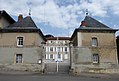
Bey mansion


Personalities
- Jacques-Eugène Feyen (1815–1908), painter and photographer
- Augustin Feyen-Perrin (1826–1888), painter
Web links
Commons : Bey-sur-Seille - Collection of images, videos and audio files