Seille (Moselle)
| Seille | ||
|
Course of the Seille |
||
| Data | ||
| Water code | FR : A7-0100 | |
| location | France | |
| River system | Rhine | |
| Drain over | Moselle → Rhine → North Sea | |
| source | in the municipality of Maizières-lès-Vic 48 ° 43 ′ 29 ″ N , 6 ° 47 ′ 46 ″ E |
|
| Source height | approx. 253 m | |
| muzzle | in the urban area of Metz in the canalized Moselle Coordinates: 49 ° 7 ′ 33 " N , 6 ° 11 ′ 7" E 49 ° 7 ′ 33 " N , 6 ° 11 ′ 7" E |
|
| Mouth height | approx. 160 m | |
| Height difference | approx. 93 m | |
| Bottom slope | approx. 0.67 ‰ | |
| length | approx. 138 km | |
| Catchment area | approx. 1348 km² | |
| Drain at the mouth |
MQ |
10.5 m³ / s |
| Left tributaries | Loutre Noire | |
| Right tributaries | Petite Seille | |
| Flowing lakes | Linderweiher | |
| Big cities | Metz | |
| Small towns | Marly | |
|
The river in Vic-sur-Seille |
||
The Seille is a right tributary of the Moselle in the French region of Grand Est .
Surname
The Seille is also called the Lorraine Seille or the Große Seille to distinguish it from the Seille , which flows into the Saône in the Burgundy region . The river was officially called Seille during German rule (1871 to 1918) until the name was changed to Selle in 1916 . The name Selz , occasionally given as a German name, is a misunderstanding that stems from the renaming of Coin-sur-Seille to Selzeck in 1915 .
geography
course
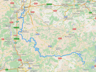
The source stream of the Seille, the Ruisseau de Guessing , rises in the Lorraine Regional Nature Park , in the municipality of Maizières-lès-Vic , changes its name several times in the source area and finally flows into the Linderweiher (French: Étang de Lindre ), which it joins Lindre-Basse leaves Seille again under his final name . The river generally drains in a north-westerly direction with strong river loops in places and flows into the Moselle after 138 kilometers in the urban area of Metz . On its way, the Seille crosses the Moselle and Meurthe-et-Moselle departments and forms the border between the two departments over a long stretch of the middle course.
Places on the river
(Order in flow direction)
Web links
- Pictures and history of the Seille
- Débits caractéristiques de la Seille (French; PDF; 27 kB)
Individual evidence
- ↑ Source geoportail.fr (1: 32,000)
- ↑ estuary geoportail.fr (1: 16,000)
- ↑ a b The information on the length of the river is based on the information about the Seille at SANDRE (French), accessed on January 7, 2012, rounded to full kilometers.
- ↑ See web link: Débits caractéristiques de la Seille
- ↑ hydro.eaufrance.fr (Station: A7881010 , option: Synthèse )
- ^ Announcement concerning the change of French brook, mountain, forest, path, valley and field names, from September 7, 1916. In: Central and District Official Gazette for Alsace-Lorraine. 1916, No. 40, pages 400-404.

