
Lorraine Regional Nature Park

The Lorraine Regional Nature Park ( French Parc naturel régional de Lorraine ) is located in the French region of Grand Est and extends over the departments of Meuse , Meurthe-et-Moselle and Moselle . The name refers to the Lorraine landscape , which until 2015 formed its own region as an administrative unit.
It consists of two separate areas. The western section is bounded by the Maas and Moselle rivers and extends to the latitude of Nancy in the south and to that of Metz in the north . The eastern section covers the area between Seille and Saar west of Sarrebourg .
Park management
The park administration is based in Pont-à-Mousson ( 48 ° 54 '28 " N , 6 ° 3' 21" E, ). The nature park was founded in 1974, covers an area of around 220,000 hectares and a catchment area of around 72,000 inhabitants, which extends over 193 communities. Eight access points are associated with the park that are outside the park:
|
West section: |
East section: |
Landscapes
In the western section, the Côtes de Meuse ridge , which stretches east of the Meuse , is overgrown by dense forests, while the ridge to the Moselle valley ( Côtes de Moselle ) is used for agriculture, mainly for viticulture. In between lie the striking plains of Woëvre and Haye , which are particularly characterized by their calcareous subsoil. There are also some wetlands around the Lac de Madine .
In the eastern section of the lake area dominated Pays des Étangs with the great lakes Etang de Lindre , Grand Etang de Mittersheim and Etang de Gondrexange , who is also from the ship channel Canal de la Marne au Rhin and the Saar channel is flown through which branches in the lake. Further to the west lies the Salzgau region (Pays du Saulnois ), which - according to its name - is shaped by the former salt mining .
Habitats
The park includes a large number of wetlands with abundant flowing water, but also stagnant water such as lakes, ponds and swamps. The occurrence of saline pools is remarkable. An endemic form of the European samphire (Salicorne de Lorraine) thrives here . But also moor plants , reeds and wet meadows give a diverse fauna an ideal habitat. 34% of the territory is covered by forest, with beech and oak forests dominating. The larger plains are covered with dry limestone grass and offer particularly warmth-seeking plants such as orchids and gentian plants as well as insects such as the praying mantis , the mountain cicada and reptiles such as snakes and lizards favorable living conditions. Former military installations and caves also allow numerous species of bats to live here for different life cycles.
Attractions

- Montsec hill
- The hill of Montsec (fr: Butte de Montsec) is located on the territory of the municipality of the same name, Montsec , which, however, formally - as an exclave - is not part of the nature park. On the top of the hill, at an altitude of 377 meters, there is a monument commemorating the offensives of the US Army against Saint-Mihiel in the First World War . The monument is classified as a monument historique .
- Pierrefort Castle
- The castle of Pierrefort (fr: Château fort de Pierrefort) was built by Pierre de Bar in 1306. Today it is located in the municipality of Martincourt and shows remains of enclosure, a covered battlement, porches and round towers.
- Aqueduct over the Moselle
- The aqueduct , which previously connected Gorze with Metz for water supply, is a Roman aqueduct, built towards the beginning of the second century. It is classified as a monument historique .

View from the hill of Montsec to the Côtes de Meuse

The Étang de Lindre
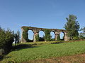
The Roman aqueduct ...

The Moselle at Pont-à-Mousson


.jpg)

See also
Web links
- Lorraine Regional Nature Park (French)