Lindre-Basse
| Lindre-Basse | ||
|---|---|---|

|
|
|
| region | Grand Est | |
| Department | Moselle | |
| Arrondissement | Sarrebourg-Château-Salins | |
| Canton | Le Saulnois | |
| Community association | Saulnois | |
| Coordinates | 48 ° 48 ' N , 6 ° 45' E | |
| height | 205-248 m | |
| surface | 8.28 km 2 | |
| Residents | 218 (January 1, 2017) | |
| Population density | 26 inhabitants / km 2 | |
| Post Code | 57260 | |
| INSEE code | 57404 | |
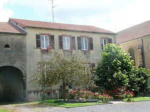
 Town hall and school building |
||
Lindre-Basse is a French commune with 218 inhabitants (as of January 1, 2017) in the Moselle department in the Grand Est region (until 2015 Lorraine ). It is located in the Lorraine Regional Nature Park , east of Metz on the banks of the Linderweiher (Étang de Lindre).
history
The pond itself was first mentioned in 1263 as Linter , Lindre-Basse was built towards the end of the 15th century.
The area belonged to the County of Zweibrücken until 1297 when it was exchanged for the Duchy of Lorraine .
From 1871 to 1918 Lindre-Basse belonged to the German Empire , but French remained the official language until the ban in 1915, the place name was then translated into Nieder-Linder . In November 1918, Lindre-Basse was returned to France.
During the Second World War , the town was occupied by the Germans in 1940, who renamed it Niederlinden until it was liberated in autumn 1944 .
Population development
| 1910 | 1962 | 1968 | 1975 | 1982 | 1990 | 1999 | 2015 |
|---|---|---|---|---|---|---|---|
| 320 | 236 | 254 | 239 | 229 | 228 | 231 | 229 |
