Cutting (Moselle)
| Cutting | ||
|---|---|---|

|
|
|
| region | Grand Est | |
| Department | Moselle | |
| Arrondissement | Sarrebourg-Château-Salins | |
| Canton | Le Saulnois | |
| Community association | Saulnois | |
| Coordinates | 48 ° 51 ′ N , 6 ° 50 ′ E | |
| height | 213-256 m | |
| surface | 5.62 km 2 | |
| Residents | 139 (January 1, 2017) | |
| Population density | 25 inhabitants / km 2 | |
| Post Code | 57260 | |
| INSEE code | 57161 | |
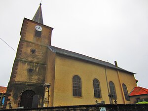
 Saint Martin Church |
||
Cutting (German Kuttingen ) is a French commune with 139 inhabitants (as of January 1, 2017) in the Moselle department in the Grand Est region (until 2015 Lorraine ). It belongs to the arrondissement of Sarrebourg-Château-Salins , to the canton of Le Saulnois and to the communal association Communauté de communes du Saulnois .
geography
Cutting is located in Saulnois , 72 kilometers northwest of Strasbourg , 56 kilometers southeast of Metz , 50 kilometers northeast of Nancy and 20 kilometers northwest of Sarrebourg , between the neighboring communities of Domnom-lès-Dieuze in the northwest, Lostroff in the northeast and Rorbach-lès-Dieuze in the South, at an altitude between 213 and 256 meters above sea level. The municipal area covers 5.62 km² (562 hectares). The hamlet L'Espérance ("The Hope") is located south of the town center at the intersection of the D27 and D38 département roads .
history
Cutting was first mentioned in a document in 1328 as Villa de Kuctinga in a contract in the copy book of the monastery of Fénétrange , in 1476 it appeared as Kuttanges . The place name is made up of the Germanic name Goddo and the place name ending -ingen . Until 1698 the village belonged to the castellany of Marimont-lès-Bénestroff , which was a Bailliage of the Duchy of Lorraine . In 1618 the municipality was the capital of a mairie which, in addition to Cutting, Domnon-lès-Dieuze , Bassing and Loudrefing included. At that time, a mairie served as the administrative body of a seigneurie .
The Duchy of Lorraine has been independent several times since it was founded as Lotharii Regnum by Lothar I. It later belonged temporarily to the Holy Roman Empire and also to France. In 1738 it was awarded to the Polish King Stanislaus I. Leszczyński (1677–1766) in the Peace of Vienna , which ended the War of the Polish Succession (1733–1738), and after his death in 1766 it fell to France.
In 1793 Cutting received in the course of the French Revolution (1789-1799) the status of a municipality and in 1801 as Kutting the right to local self-government. From 1801 to 1871 it belonged to the former Meurthe department , which was renamed the Meurthe-et-Moselle department in 1871 . In 1871 the community was incorporated into the newly created realm of Alsace-Lorraine of the German Empire due to changes in territory due to the course of the Franco-German War (1870–1871) . The realm of Alsace-Lorraine existed until the end of the First World War (1914–1918) and was then dissolved. Cutting was in the Moselle department at that time, this change was retained in 1918 when Moselle was re-assigned to France.
Population development
| year | 1962 | 1968 | 1975 | 1982 | 1990 | 1999 | 2007 | 2015 |
| Residents | 171 | 206 | 184 | 165 | 155 | 147 | 132 | 135 |
coat of arms
The coat of arms of the municipality is silver with a red coat ( chape is the opposite of a heraldic tip ). In the middle there is a black paw cross , in the upper corners there are two silver Alérions (mutilated eagles). The cross reminds of the Teutonic Order to which the parish of Cutting was subordinate. The Alérions are reminiscent of the Duchy of Lorraine and the mantle is the attribute of the patron saint Martin of Tours .
Personalities
- Jean-Martin Moyë (* on January 27, 1730 in Cutting, † on May 4, 1793 in Trier ), missionary in China, founder of the order of the Sœurs de la Providence
Individual evidence
- ↑ Mairie de Cutting, Annuaire-mairie.fr (French)
- ↑ Village de Cutting, Actuacity.com (French)
- ^ Ernest Nègre: Toponymie générale de la France . tape 2 . Librairie Droz, 1996, ISBN 978-2-600-00133-5 , pp. 781 ( in Google Books [accessed April 10, 2010]). (French)
- ^ Henri Lepage: Dictionnaire topographique du département de la Meurthe . In: Société d'archéologie lorraine et du Musée historique lorrain (ed.): Dictionnaire topographique de la France . 6th edition. tape 14 , no. 18 . Imprimerie impériale, Paris 1862, p. 39 + 47 + 87 ( in Google Books [accessed April 10, 2010]). (French)
- ↑ Gerhard Köbler : Historical Lexicon of the German Lands: the German territories from the Middle Ages to the present . In: Beck Historical Library . 7th edition. CH Beck, Munich 2007, ISBN 978-3-406-54986-1 , p. 391 f . ( in Google Books [accessed April 10, 2010]). (French)
- ↑ Cutting Notice Communale, Cassini.ehess.fr (French)
- ↑ Union des Cercles Génealogiques Lorrains (French)
