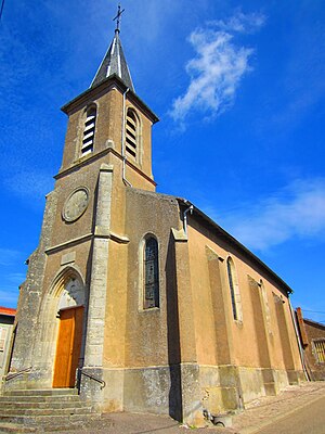
Alaincourt-la-Cote
| Alaincourt-la-Cote | ||
|---|---|---|

|
|
|
| region | Grand Est | |
| Department | Moselle | |
| Arrondissement | Sarrebourg-Château-Salins | |
| Canton | Le Saulnois | |
| Community association | Saulnois | |
| Coordinates | 48 ° 54 ' N , 6 ° 20' E | |
| height | 195-399 m | |
| surface | 4.17 km 2 | |
| Residents | 149 (January 1, 2017) | |
| Population density | 36 inhabitants / km 2 | |
| Post Code | 57590 | |
| INSEE code | 57010 | |
 Saints-Côme-et-Damien church |
||
Alaincourt-la-Côte is a French commune with 149 inhabitants (as of January 1, 2017) in the Moselle department in the Grand Est region (until 2015 Lorraine ). It belongs to the arrondissement of Sarrebourg-Château-Salins , to the canton of Le Saulnois and to the communal association Communauté de communes du Saulnois .
geography
Alaincourt-la-Côte is located about 30 kilometers southeast of Metz in the Saulnois at an altitude between 195 and 399 meters above sea level. The municipality on the border with the Meurthe-et-Moselle department covers 4.17 km². Neighboring municipalities are Foville , Liocourt , Xocourt , Puzieux , Graincourt and Thézay-Saint-Martin .
history
Alaincourt-la-Côte is located near the Roman road from Metz (Divodurum) to Delme (Duodecimum) .
The village belonged to Delme and was given together with that municipality in 1661 by Duke Charles IV of Lorraine (1604–1675) due to the Treaty of Vincennes to King Louis XIV (1638–1715) of France.
1793 received Alaincourt-la-Côte (as Alaincourt ) in the course of the French Revolution (1789-1799) the status of a municipality and 1801 (as Alincourt ) the right to local self-government. From 1801 to 1871 it belonged to the former Meurthe department , which was renamed the Meurthe-et-Moselle department in 1871 . In 1871 the community was incorporated into the newly created realm of Alsace-Lorraine of the German Empire due to changes in territory due to the course of the Franco-German War (1870–1871) . The realm of Alsace-Lorraine existed until the end of the First World War (1914–1918) and was then dissolved. At that time, Alaincourt-la-Côte was in the Moselle department, this change was retained in 1918 when Moselle was re-assigned to France. As a French-speaking town, Alaincourt-la-Côte was one of the last 247 communities whose name was Germanized on September 2, 1915. The name was changed to "Allenhofen" and was the official place name until 1918.
Population development
| year | 1962 | 1968 | 1975 | 1982 | 1990 | 1999 | 2007 |
| Residents | 92 | 110 | 82 | 85 | 82 | 91 | 128 |
coat of arms
The coat of arms of the municipality reminds of the importance of the Duchy of Lorraine , whose coat of arms contains three silver Alérions (eagles). The municipal coat of arms shows two silver Alérions on a red background, between which there is a silver pole , which represents the military road that led through Alaincourt-la-Côte after 1661.
Economy and Infrastructure
The image of the place is characterized by pastures and fields. The main occupations in Alaincourt-la-Côte are trade and agriculture (growing of grain).
Web links
- Alaincourt-la-Côte on cartesfrance.fr in French
- Alaincourt-la-Côte on annuaire-mairie.fr in French
Individual evidence
- ↑ VR6-Itinéraires romains en France (French) Retrieved February 24, 2010.
- ^ Mairie Alaincourt-la-Côte: Alaincourt-la-Côte - Carte communale . Ed .: Département de la Moselle. July 2011 (French, PDF document , see p. 7 [accessed on March 29, 2015]).
- ^ Alaincourt-la-Côte on cassini.ehess.fr (French). Retrieved February 24, 2010.
- ↑ Les 247 dernières communes à noms français, débaptisées seulement le 2 septembre 1915 (French) Accessed February 24, 2010.
- ↑ Union of Cercles GENEALOGIQUES Lorrain (French) Accessed on 24 February, 2010.
- ↑ Alaincourt-la-Côte - Dossier complet on insee.fr in French, accessed on March 29, 2015, cf. Section Chiffres clés caractéristiques des entreprises et des établissements .
