Virming
| Virming | ||
|---|---|---|

|
|
|
| region | Grand Est | |
| Department | Moselle | |
| Arrondissement | Sarrebourg-Château-Salins | |
| Canton | Le Saulnois | |
| Community association | Saulnois | |
| Coordinates | 48 ° 57 ' N , 6 ° 45' E | |
| height | 221-266 m | |
| surface | 10.77 km 2 | |
| Residents | 296 (January 1, 2017) | |
| Population density | 27 inhabitants / km 2 | |
| Post Code | 57340 | |
| INSEE code | 57723 | |
| Website | Virming | |
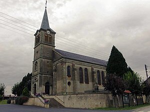
 Saint-Pierre church |
||
Virming (German Wirmingen , Lorraine Wirminge ) is a French commune with 296 inhabitants (as of January 1, 2017) in the Moselle department in the Grand Est region (until 2015 Lorraine ), four kilometers north of Bénestroff .
The village was destroyed in the Thirty Years' War and only rebuilt a little further south in 1656.
The hamlets belong to the municipality of Virming
- Ibrick (southwest),
- Obrick (northeast) and
- Besville ( Besweiler , located to the south).
Population development
| year | 1962 | 1968 | 1975 | 1982 | 1990 | 1999 | 2007 |
| Residents | 276 | 293 | 290 | 278 | 308 | 284 | 268 |
Web links
Commons : Virming - collection of images, videos and audio files
