
Lixheim
| Lixheim | ||
|---|---|---|

|
|
|
| region | Grand Est | |
| Department | Moselle | |
| Arrondissement | Sarrebourg-Château-Salins | |
| Canton | Phalsbourg | |
| Community association | Pays de Phalsbourg | |
| Coordinates | 48 ° 47 ' N , 7 ° 9' E | |
| height | 268–336 m | |
| surface | 3.96 km 2 | |
| Residents | 579 (January 1, 2017) | |
| Population density | 146 inhabitants / km 2 | |
| Post Code | 57635 | |
| INSEE code | 57407 | |
 Mairie Lixheim |
||

Lixheim is a French commune with 579 inhabitants (as of January 1, 2017) in the Moselle department in the Grand Est region (until 2015 Lorraine ). It belongs to the Sarrebourg-Château-Salins arrondissement and the Pays de Phalsbourg municipal association . The inhabitants call themselves Lixins.
geography
Lixheim is about nine kilometers north-east of Sarrebourg at an altitude between 268 and 336 m above sea level.
Neighboring communities of Lixheim are Schalbach in the north, Fleisheim in the northeast, Hérange in the east, Brouviller in the south and Vieux-Lixheim in the west.
history
In the municipality there used to be a Benedictine monastery, the Lixheim monastery, which was founded in 1107 and closed in 1550; The remains of this monastery were then completely destroyed in the Thirty Years' War .

The place itself was founded in 1608 by Georg Gustav von Pfalz-Veldenz as a place of refuge for Protestants from the Duchy of Lorraine . In 1623, Duke Heinrich II of Lorraine acquired Lixheim and the other Palatinate possessions in the region. In the following year the Duke transferred the purchased areas and the Pfalzburg, which had already been bought in 1583, as well as the Einarzhausen office to Johann von Guise. On February 12, 1629 Emperor Ferdinand II elevated the territory to the imperial principality of Lixheim.
In 1702 the principality fell to the Duchy of Lorraine . Lixheim has belonged to France since 1766 (1870–1918 to the German Empire).
Lixheim was laid out like a chessboard. The small river Bruche was divided and led around Lixheim north and south and dammed in the north-west. This created a moat around the city walls, which had two gates. Today the river flows again in its old bed, the fortifications no longer exist apart from the remains of ramparts and ditches. However, the entire system can still be seen well on satellite images. Relatively much has been preserved from the building fabric from the founding time within the former walls.
Population development
| year | 1962 | 1968 | 1975 | 1982 | 1990 | 1999 | 2007 | 2015 |
| Residents | 598 | 630 | 651 | 588 | 527 | 572 | 559 | 606 |
Attractions
- entire urban ensemble, in particular
- Saint-Antoine church from the 18th century, rebuilt in the 19th century
- Protestant church with outbuildings that on the remains of the former monastery Lixheim emerged
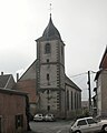
Saint-Antoine church

West portal of the Saint-Antoine church

Evangelical church with outbuildings (former monastery)


