Diane-Capelle
| Diane-Capelle | ||
|---|---|---|

|
|
|
| region | Grand Est | |
| Department | Moselle | |
| Arrondissement | Sarrebourg-Château-Salins | |
| Canton | Sarrebourg | |
| Community association | Sarrebourg Moselle Sud | |
| Coordinates | 48 ° 44 ′ N , 6 ° 56 ′ E | |
| height | 259-302 m | |
| surface | 6.07 km 2 | |
| Residents | 221 (January 1, 2017) | |
| Population density | 36 inhabitants / km 2 | |
| Post Code | 57830 | |
| INSEE code | 57175 | |
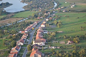
 Aerial view of Diane-Capelle, in the background on the left the stock pond |
||
Diane-Capelle (German Dianenkappel , 1871-1894 Kappel , 1940-1944 Jägersdorf ) is a French commune with 221 inhabitants (as of January 1, 2017) in the Moselle department in the Grand Est region (until 2015 Lorraine ).
geography
The municipality is located nine kilometers west of Sarrebourg on the Saar Canal . The hamlets of Houillons and Tuillier and the southern part of the Stockweiher belong to the community of Diane-Capelle .
history
From October 1, 1972 to January 1, 1985 Diane-Capelle was merged with Kerprich-aux-Bois to form the community of Diane-et-Kerprich .
Population development
| year | 1962 | 1968 | 1975 | 1982 | 1990 | 1999 | 2007 | 2015 |
| Residents | 220 | 233 | 200 | 180 | 189 | 216 | 224 | 225 |
Web links
Commons : Diane-Capelle - collection of pictures, videos and audio files
