Domnom-lès-Dieuze
| Domnom-lès-Dieuze | ||
|---|---|---|

|
|
|
| region | Grand Est | |
| Department | Moselle | |
| Arrondissement | Sarrebourg-Château-Salins | |
| Canton | Le Saulnois | |
| Community association | Saulnois | |
| Coordinates | 48 ° 52 ' N , 6 ° 49' E | |
| height | 213-290 m | |
| surface | 6.63 km 2 | |
| Residents | 81 (January 1, 2017) | |
| Population density | 12 inhabitants / km 2 | |
| Post Code | 57260 | |
| INSEE code | 57181 | |
 Saint-Matthieu church |
||
Domnom-lès-Dieuze (German Dommenheim ) is a French commune with 81 inhabitants (as of January 1, 2017) in the Moselle department in the Grand Est region (until 2015 Lorraine ). It belongs to the arrondissement of Sarrebourg-Château-Salins , to the canton of Le Saulnois and to the communal association Communauté de communes du Saulnois .
geography
Domnom-lès-Dieuze is located in the Saulnois , 24 kilometers northwest of Sarrebourg and about ten kilometers northeast of Dieuze . The departmental road D27 runs through the community and connects it with the neighboring communities of Bassing and Cutting .
history
Domnom-lès-Dieuze was first mentioned in 1297 in the copy book of the Vergaville monastery as Domenheim . The place name is made up of the Germanic name Duomo (n) and the place name ending -heim . The vowels "o" and "e" in Domonhem have been twisted to Domenhom . Later the "e" was omitted entirely. 1793 received Domnom-lès-Dieuze in the course of the French Revolution (1789-1799) as a Dominom the status of a municipality and 1801 as a Domnom the right to local self-government. It was given its current name in July 1994, before that (after 1862) it was called Domnon-lès-Dieuze.
The village belonged to the Seigneurie of Marimont-lès-Bénestroff . Marimont-lès-Bénestroff was the seat of a Bailliage of the Habsburgs . Around 1618 Domnom-lès-Dieuze belonged to a Mairie (mayor's office) whose main town was Cutting. From 1698 it belonged to the Prévoté ( Vogtei ) of Dieuze . The parish of Domnom-lès-Dieuze was subordinate to the Archpriest of Vergaville .
Domnom-lès-Dieuze was completely destroyed in 1635 during the Thirty Years War , after the peace treaty only two families lived there in 1650.
In 1793 Domnom-lès-Dieuze received the status of a municipality in the course of the French Revolution and in 1801 the right to local self-government. From 1801 to 1871 the community belonged to the former French department of Meurthe , which was renamed the department of Meurthe-et-Moselle in 1871 . In 1871 the community was incorporated into the newly created realm of Alsace-Lorraine of the German Empire due to changes in territory due to the course of the Franco-German War (1870–1871) . The realm of Alsace-Lorraine existed until the end of the First World War (1914–1918) and was then dissolved. Domnom-lès-Dieuze was located in the Moselle department at that time, this change was retained in 1918 when Moselle was again assigned to France.
| year | 1793 | 1836 | 1861 | 1872 | 1911 | 1921 | 1936 | 1946 | 1999 | 2007 |
|---|---|---|---|---|---|---|---|---|---|---|
| Residents | 256 | 393 | 304 | 302 | 244 | 213 | 187 | 191 | 100 | 104 |
The community had the most inhabitants in 1836 (396), after which the population fell until 1999 (100 inhabitants).
coat of arms
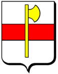
The coat of arms of the municipality is silver with a red horizontal stripe, and until then corresponds to the coat of arms of Marimont-lès-Bénestroff. In the middle the coat of arms shows a golden ax, an attribute of the apostle Matthias , the patron saint of the village. The metallic heraldic colors silver and gold are shown on the coats of arms in white and yellow.
Web links
Individual evidence
- ↑ Domnom-lès-Dieuze on Actuacity.com (French). Retrieved April 30, 2010
- ^ A b Henri Lepage: Dictionnaire topographique du département de la Meurthe . In: Société d'archéologie lorraine et du Musée historique lorrain (ed.): Dictionnaire topographique de la France . 6th edition. tape 14 , no. 18 . Imprimerie impériale, Paris 1862, p. 39 + 42 + 44 + 87 + 151 ( from Google Books [accessed May 1, 2010]). (French)
- ^ Ernest Nègre: Toponymie générale de la France . tape 2 . Librairie Droz, 1996, ISBN 978-2-600-00133-5 , pp. 1023 ( in Google Books [accessed April 30, 2010]). (French)
- ↑ a b Domnom-lès-Dieuze on Cassini.ehess.fr (French) Retrieved April 30, 2010
- ↑ a b Union des Cercles Génealogiques Lorrains ( Memento of the original from January 9, 2010 in the Internet Archive ) Info: The archive link has been inserted automatically and has not yet been checked. Please check the original and archive link according to the instructions and then remove this notice. (French) Retrieved April 30, 2010
