
Vasperviller
| Vasperviller | ||
|---|---|---|

|
|
|
| region | Grand Est | |
| Department | Moselle | |
| Arrondissement | Sarrebourg-Château-Salins | |
| Canton | Phalsbourg | |
| Community association | Sarrebourg Moselle Sud | |
| Coordinates | 48 ° 38 ′ N , 7 ° 4 ′ E | |
| height | 275-374 m | |
| surface | 1.54 km 2 | |
| Residents | 316 (January 1, 2017) | |
| Population density | 205 inhabitants / km 2 | |
| Post Code | 57560 | |
| INSEE code | 57697 | |

Vasperviller ( German Wasperweiler , Lorraine Woschperwiller ) is a French commune with 316 inhabitants (as of January 1, 2017) in the Moselle department in the Grand Est region (until 2015 Lorraine ), about eleven kilometers south of Sarrebourg on the Red Saar .
The village was completely depopulated during the Thirty Years War and came to France in 1661. It was only rebuilt and settled in the 18th century.
The two farms belong to the municipality of Vasperviller
- La Marcarerie ( dairy ) and
- La Rouge Eau ( red water ).
Population development
| year | 1962 | 1968 | 1975 | 1982 | 1990 | 1999 | 2007 | 2015 |
|---|---|---|---|---|---|---|---|---|
| Residents | 310 | 324 | 293 | 299 | 284 | 281 | 291 | 316 |
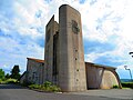
Sainte-Thérèse church

railway station


Web links
Commons : Vasperviller - collection of images, videos and audio files