Hattigny
| Hattigny | ||
|---|---|---|

|
|
|
| region | Grand Est | |
| Department | Moselle | |
| Arrondissement | Sarrebourg-Château-Salins | |
| Canton | Phalsbourg | |
| Community association | Sarrebourg Moselle Sud | |
| Coordinates | 48 ° 38 ′ N , 6 ° 58 ′ E | |
| height | 291-372 m | |
| surface | 13.14 km 2 | |
| Residents | 187 (January 1, 2017) | |
| Population density | 14 inhabitants / km 2 | |
| Post Code | 57790 | |
| INSEE code | 57302 | |
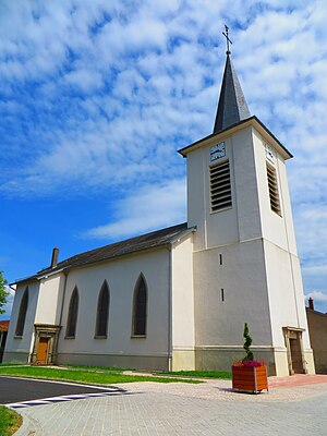
 Church of St. Peter and Paul |
||
Hattigny is a French commune with 187 inhabitants (as of January 1, 2017) in the Moselle department in the Grand Est region (until 2015 Lorraine ). It belongs to the arrondissement of Sarrebourg-Château-Salins .
geography
The municipality of Hattigny is located at the foot of the Vosges , about 13 kilometers south of Sarrebourg on the border with the Meurthe-et-Moselle department . The municipality covers 13.14 km².
To the southwest is the Étang de Hattigny ( Hattinger Weiher ). The two hamlets belong to the community
- Risholz ( Risholz ), to the west, and
- Bonlieu ( Guthof ), located to the south.
history
The place was also known under the name Hittingen in the Middle Ages and has belonged to France since 1661. In 1830 it still had 599 inhabitants.
1915-18 and 1940-44 he was named Hattingen .
Population development
| year | 1962 | 1968 | 1975 | 1982 | 1990 | 1999 | 2007 |
|---|---|---|---|---|---|---|---|
| Residents | 227 | 227 | 209 | 209 | 187 | 160 | 190 |
Culture and sights
There is a park of the Center Parcs hotel chain in the municipality . Its name is "Domaine les Trois Forêts" and it is also the largest Center Parc in Europe. It is located on 435 hectares of forest in the direction of Niderhoff and is crossed by a river. The address is Rue de Bertrambois 1 57790 Hattigny.
