Azoudange
| Azoudange | ||
|---|---|---|

|
|
|
| region | Grand Est | |
| Department | Moselle | |
| Arrondissement | Sarrebourg-Château-Salins | |
| Canton | Sarrebourg | |
| Community association | Sarrebourg Moselle Sud | |
| Coordinates | 48 ° 44 ' N , 6 ° 49' E | |
| height | 217-302 m | |
| surface | 15.73 km 2 | |
| Residents | 118 (January 1, 2017) | |
| Population density | 8 inhabitants / km 2 | |
| Post Code | 57810 | |
| INSEE code | 57044 | |
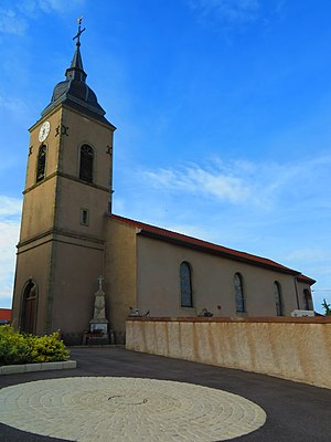
 Church of the Nativity of Mary |
||
Azoudange is a French commune with 118 inhabitants (as of January 1, 2017) in the Moselle department in the Grand Est region (until 2015 Lorraine ).
geography
The municipality of Azoudange is located in the source area of the Seille between Linderweiher ( Étang de Lindre ) and Gunderchinger Weiher ( Étang de Gondrexange ), about 20 kilometers west of Sarrebourg . The municipality of Azoudange is part of the Lorraine Regional Nature Park .
The two hamlets belong to the municipality:
- Toupee ( Tupethof ), to the northwest, and
- Romécourt ( Römerhof ) including the castle of the same name, located to the south.
history
The village has belonged to France since 1681. From 1915 to 1918 it had the Germanized name Anslingen an der Duss , 1940–1944 it was called Aßlingen .
Population development
| year | 1962 | 1968 | 1975 | 1982 | 1990 | 1999 | 2007 | 2017 |
| Residents | 161 | 182 | 154 | 123 | 103 | 106 | 114 | 118 |
See also
Web links
Commons : Azoudange - collection of images, videos and audio files
Individual evidence
- ↑ Eisenbahndirektion Mainz (Ed.): Official Journal of the Royal Prussian and Grand Ducal Hessian Railway Directorate in Mainz of October 30, 1915, No. 54. Announcement No. 721, p. 350f.
