
Hilbesheim
| Hilbesheim | ||
|---|---|---|

|
|
|
| region | Grand Est | |
| Department | Moselle | |
| Arrondissement | Sarrebourg-Château-Salins | |
| Canton | Sarrebourg | |
| Community association | Sarrebourg Moselle Sud | |
| Coordinates | 48 ° 47 ' N , 7 ° 6' E | |
| height | 257-337 m | |
| surface | 7.52 km 2 | |
| Residents | 607 (January 1, 2017) | |
| Population density | 81 inhabitants / km 2 | |
| Post Code | 57400 | |
| INSEE code | 57324 | |

Hilbesheim is a French commune with 607 inhabitants (as of January 1, 2017) in the Moselle department in the Grand Est region (until 2015 Lorraine ). It belongs to the arrondissement of Sarrebourg-Château-Salins and the canton of Sarrebourg (until 2015: canton of Fénétrange ).
geography
Hilbesheim is located five kilometers northeast of Sarrebourg on the border with the Bas-Rhin department at an altitude between 257 and 337 m above sea level. The municipality covers 7.52 km².
The two farms Ferme Bellevue ( Kastelwalderhof ) and Vieux-Moulin ( Altmühle ) belong to the municipality of Hilbesheim .
history
The village was first mentioned in 713 as Cilbociaga and was still called Hilbichheim until 1869 . In 1766 it became part of France, from 1871 to 1918 it became part of the German Empire and from 1919 back to France.
Population development
| year | 1962 | 1968 | 1975 | 1982 | 1990 | 1999 | 2007 |
| Residents | 428 | 432 | 473 | 469 | 472 | 515 | 600 |
Attractions
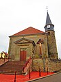
Saint-Brice church

Chapel of Sainte-Anne

