Vannecourt
| Vannecourt | ||
|---|---|---|

|
|
|
| region | Grand Est | |
| Department | Moselle | |
| Arrondissement | Sarrebourg-Château-Salins | |
| Canton | Le Saulnois | |
| Community association | Saulnois | |
| Coordinates | 48 ° 53 ' N , 6 ° 33' E | |
| height | 213-336 m | |
| surface | 9.55 km 2 | |
| Residents | 79 (January 1, 2017) | |
| Population density | 8 inhabitants / km 2 | |
| Post Code | 57340 | |
| INSEE code | 57692 | |
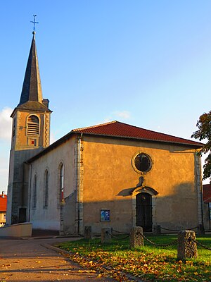
 Saint-Denis church |
||
Vannecourt is a French commune with 79 inhabitants (as of January 1, 2017) in the Moselle department in the Grand Est region (until 2015 Lorraine ). It is 38 kilometers southeast of Metz and 34 kilometers northeast of Nancy .
The village has belonged to France since 1766.
During the military occupations in World War I and World War II (June 1940 to autumn 1944) the German name Warnhofen was used.
Population development
| year | 1962 | 1968 | 1975 | 1982 | 1990 | 1999 | 2007 |
| Residents | 60 | 82 | 77 | 66 | 83 | 60 | 85 |
Web links
Commons : Vannecourt - collection of images, videos and audio files
Footnotes
- ↑ luftlinie.org to Metz and Nancy
- ^ After the death of the Polish King Stanislaus I. Leszczyński (February 23, 1766), the Duchy of Lorraine fell to France as agreed.
